
Hiking Through Rwanda’s Bamboo Forests
Hiking through Rwanda’s bamboo forests takes place primarily in Volcanoes National Park in the northwest, where the bamboo belt between approximately 2,400 and 2,900 metres forms the primary habitat of mountain gorillas and golden monkeys — accessible on hiking permits costing $75 for the Bisoke day hike or $100 for golden monkey trekking in 2026. A secondary bamboo forest zone exists in Nyungwe Forest National Park in the southwest, where the Bisinda Trail and upper sections of several park routes pass through bamboo-dominated areas at higher elevations. All bamboo forest hiking in Rwanda’s national parks requires a guide provided by the Rwanda Development Board and entry through the standard permit system.
Rwanda’s bamboo forests are part of the Afromontane vegetation sequence, occupying the elevation band between the lower mixed montane forest and the higher Hagenia woodland on the Virunga volcanoes and in Nyungwe’s upper zones. The bamboo species dominant in Volcanoes National Park is Arundinaria alpina (African alpine bamboo), which forms dense single-species stands where culms reach five to eight metres in height and close canopy overhead. This structural density — the bamboo culms creating a green tunnel effect — is a distinctive physical environment that differs markedly from open forest hiking and requires attention to the trail to maintain direction when the canopy closes tightly.
$100 per person for foreign non-residents. Primary bamboo forest hiking permit in Volcanoes National Park. Two habituated golden monkey troops in the bamboo zone. Briefing at Kinigi HQ 7:30 a.m. One hour with the troop.
$75 per person. Day hike to 3,711m crater summit. Bamboo forest section covers the lower quarter of the ascent from 2,400 to 2,900m. Guide included. 16 permits per day. 6 to 8 hours round trip.
$400 per person. Two-day trek. Day one passes through bamboo forest on the initial ascent. Some of the longest bamboo forest hiking distance of any Volcanoes National Park route. Guide and camping included.
$50 per person per day (day 1), $25 thereafter. The Bisinda Trail and several upper-elevation Nyungwe routes pass through bamboo forest zones. Guide included. 130km trail network.
Bamboo Forest Hiking in Volcanoes National Park: The Gorilla and Golden Monkey Habitat
The bamboo belt of Volcanoes National Park is the most ecologically significant bamboo forest in Rwanda. African alpine bamboo forms a vegetation zone of approximately 500 metres in altitude depth around the lower slopes of all six Rwandan Virunga volcanoes, and this zone is the primary feeding and movement habitat of two of the park’s most prominent species. Mountain gorilla families including Susa, Karisimbi, and Sabyinyo range through the bamboo on a daily basis in search of young bamboo shoots, which constitute a major part of their seasonal diet. Golden monkey troops of 80 to 100 individuals feed heavily in the bamboo zone throughout the year.
Hiking through the bamboo forest on the Bisoke, Karisimbi, Muhabura, or Sabyinyo trails involves dense canopy conditions that reduce light levels to approximately 20 to 40% of open conditions. The trail surface through bamboo sections is compressed leaf litter and root-crossed earth, which provides reasonable grip in dry conditions but becomes slippery when wet. The close spacing of bamboo culms on either side of the trail path means hikers move in single file. Rangers on all Volcanoes National Park trails have experience navigating through bamboo forest off-trail when pursuing gorilla families, a skill that occasionally comes into use when the hiking group needs to leave the trail to approach or track a gorilla family through the dense stands.
The golden monkey trekking permit at $100 per person provides the most bamboo-forest-focused hiking experience available in Volcanoes National Park. Both habituated golden monkey troops — the Sabyinyo troop of up to 100 individuals and the Karisimbi troop — range entirely within the bamboo zone, meaning the entire trek from departure to return is conducted in bamboo forest. Sessions of 90 minutes to three hours (briefing, search, one-hour observation, return) are all spent within the bamboo belt, providing a more concentrated bamboo forest experience than the volcano summit hikes, which move through the bamboo zone only in their lower sections.
What Lives in Rwanda’s Bamboo Forests
The bamboo forests of Volcanoes National Park support species that depend on this specific vegetation type. Beyond mountain gorillas and golden monkeys, the bamboo zone holds the Dusky Crimsonwing, a finch-like Albertine Rift endemic bird that feeds on bamboo seeds and is rarely seen outside this habitat. The Rwenzori Double-collared Sunbird visits bamboo flower heads for nectar and is a reliable bamboo zone bird species throughout the dry season. Bamboo vipers — mildly venomous green snakes — are occasional encounters in the lower bamboo sections, particularly when moving off-trail.
The bamboo forest’s acoustic environment is distinctive. The hollow culms flex and knock against each other in wind, producing a dry percussive sound. Mountain gorillas drum on bamboo culms with their hands as a communication behaviour, a sound that carries considerable distance through the forest and is a key indicator of proximity when rangers are tracking a gorilla family. Golden monkeys are highly vocal within bamboo stands, their calls carrying through the restricted visibility of the dense vegetation.
Bamboo Forest Hiking in Nyungwe Forest National Park
Nyungwe Forest National Park has secondary bamboo zones at its higher elevations, concentrated in the upper sections of the park’s western and northern terrain. The Bisinda Trail, a 3.6-kilometre moderate-level route from Uwinka Reception Centre, crosses through a bamboo and rainforest section before entering richer mixed montane forest — making it one of the more productive trails for experiencing the transition between Nyungwe’s forest types in a relatively short distance. Several other Nyungwe trails including the upper sections of the Congo Nile Divide trail pass through bamboo-dominated areas on the high-altitude western ridgeline.
Nyungwe’s bamboo zones are less extensive than those of Volcanoes National Park and support a different species community. Chimpanzees use bamboo areas seasonally and are occasionally encountered in the bamboo sections of the park’s central trails. L’Hoest’s monkeys, which favour dense forest cover, are often seen in Nyungwe’s bamboo margins. The park’s bird diversity is high throughout all vegetation zones, and the bamboo sections support several Albertine Rift endemic species including the Dusky Crimsonwing — the same species seen in the Virunga bamboo — alongside more generalist forest birds.
Photography in Rwanda’s Bamboo Forests
Bamboo forest photography in Rwanda presents specific technical challenges. The closed canopy in dense bamboo stands reduces available light to levels requiring high ISO settings — typically 3,200 to 6,400 on a modern full-frame body — combined with a wide aperture on a telephoto lens. Fast shutter speeds of 1/400 second or above are necessary to freeze subject movement; bamboo culms sway in any wind, and golden monkeys move rapidly through the stands. A 100 to 400mm zoom lens handles the variable distances encountered when subjects move through the bamboo, from close-range encounters at 10 metres to elevated canopy shots at 40 metres.
The visual character of bamboo forest photography is dominated by vertical lines — the culms create a regular pattern of green verticals that frame wildlife subjects differently from the more chaotic branching structure of broadleaf forest. When gorillas or golden monkeys are viewed against a bamboo backdrop, the vertical culm pattern separates the subject from the background more cleanly than a mixed forest environment. Overcast light conditions, common on Rwanda’s volcanic slopes, reduce harsh shadows between culms and produce even exposure across the subject without the hot spots that direct dappled sunlight creates in forest photography.
Bamboo shoots are most abundant in the wet season, concentrating gorillas and golden monkeys in more predictable feeding areas within the bamboo zone. Trail surfaces in bamboo sections become muddier but the animals are often more accessible. Bamboo photography benefits from greener culms and cleaner leaf surfaces after rain.
Trail conditions in bamboo sections are firmer and safer on steep descents. Mountain gorillas and golden monkeys range more widely in search of food beyond bamboo shoots, which can extend trek times. Summit views above the bamboo zone are clearest in the dry months.
Planning Bamboo Forest Hikes in Rwanda
Bamboo forest hiking in Volcanoes National Park requires a permit booked through the Rwanda Development Board at rdb.rw. The golden monkey trekking permit at $100 provides the most focused bamboo forest experience. The Bisoke hike at $75 passes through bamboo forest on its lower third. Both depart from Kinigi Park Headquarters at 7:00 to 7:30 a.m. after permit verification and ranger briefing. A 4WD vehicle is needed to reach Kinigi from Musanze, and most lodge operators in the area provide early morning transfers.
Nyungwe Forest bamboo trail sections are covered under the standard park day permit of $50 per person. The Bisinda Trail and upper-elevation routes that pass through bamboo are accessible from Uwinka Reception Centre. Guides at Uwinka can identify which trails pass through significant bamboo sections and adjust the day route to match specific interests in bamboo forest hiking. Multi-day Nyungwe permits at $25 per person per day from day two make extended bamboo trail exploration cost-efficient for visitors planning three or more days in the park.
Why do mountain gorillas live in bamboo forests?
Mountain gorillas in the Virunga range use bamboo forests primarily for feeding during the wet season when bamboo shoots are most abundant. Shoots are nutritious and high in water content, providing both food and hydration. During the dry season, gorilla families range beyond the bamboo zone into higher-elevation Hagenia woodland and open heath in search of alternative food sources including fruit, leaves, and bark. The bamboo zone’s dense cover also provides shelter from observation and protection for families with infants.
Are bamboo snakes a real risk during hiking in Volcanoes National Park?
Bamboo vipers are present in Volcanoes National Park’s bamboo zone and are occasionally encountered when rangers or trekking groups move off-trail through dense bamboo. They are mildly venomous — their bites require medical attention but are not typically life-threatening to healthy adults. Wearing long trousers and avoiding placing hands in dense vegetation without visual inspection reduces encounter risk. Rangers are aware of their presence and experienced in safe movement through bamboo territory. In practice, bamboo viper encounters on hiking trails are rare events rather than a routine risk.
Is bamboo forest hiking in Nyungwe different from in Volcanoes?
Yes. Nyungwe’s bamboo zones are smaller in extent, less continuous, and located at higher elevations within a predominantly non-bamboo montane rainforest. The Nyungwe bamboo sections on the Bisinda Trail and upper routes are transitional zones rather than the dominant vegetation type that the Virunga bamboo belt represents. Gorillas are not present in Nyungwe — the park holds chimpanzees, colobus monkeys, and other primate species. Nyungwe bamboo hiking is an element of a broader forest hiking experience rather than the central theme it represents in the Virunga context.
How long is the bamboo forest section on the Bisoke hike?
The bamboo forest zone on the Bisoke summit hike covers the section between approximately 2,400 metres (the trailhead) and 2,900 metres, representing roughly the lower quarter of the total elevation gain to the 3,711-metre summit. At a moderate hiking pace, this section takes 60 to 90 minutes on the ascent and slightly less on the descent. The bamboo transitions to Hagenia-Hypericum woodland at approximately 2,900 metres, where the canopy opens considerably and views of the surrounding landscape become available.
Can I enter the bamboo forest without a permit in Rwanda?
No. The bamboo forests within Volcanoes National Park and Nyungwe Forest National Park are protected areas and require the appropriate permits for entry. Entering the park without a permit is prohibited by Rwandan law and would result in intervention by park rangers. The park boundaries in the Kinigi area of Volcanoes National Park are adjacent to community farmland, and the boundary is clearly demarcated. All visitors must purchase and present valid permits at the park headquarters before entering any section of the park’s bamboo or other forest zones.
Best Hiking Trails in Rwanda
The best hiking trails in Rwanda in 2026 include the Mount Bisoke summit trail ($75, crater lake, 3,711m) in Volcanoes National Park, the Igishigishigi Trail ($50 Nyungwe park permit, leads to East Africa’s longest zipline and canopy walkway), the Isumo Waterfall Trail ($50, 10.6km), the Congo Nile Divide Trail ($50, 42.2km, 3 days) in Nyungwe Forest, the Kamiranzovu Swamp and Waterfall Trail ($50, 3-hour hike), and the full Congo Nile Trail (no permit, 227km) along Lake Kivu. Rwanda’s 130-kilometre Nyungwe trail network and the five Virunga volcano hike routes together cover every terrain type from ancient rainforest to high-altitude subalpine, all within a country that takes less than six hours to cross by road.
Hiking in Rwanda divides between two primary park systems and one public trail. Nyungwe Forest National Park has over 15 named trails ranging from 2.1 to 42 kilometres, covered under a single daily park permit of $50 for foreign non-residents (first day), with a reduced rate of $25 per day from the second day. Volcanoes National Park has five volcano summit hike permits at $75 each (Bisoke, Muhabura, Sabyinyo, Gahinga, and Fossey) and one multi-day permit for Karisimbi at $400. The Congo Nile Trail requires no permit. All national park trails require a guide provided by the Rwanda Development Board.
$50 per person day 1. $25 per person from day 2 onwards. Covers all 15 trails in the park’s 130km network. Guide included. Night walks $40 extra. Best value hiking permit in Rwanda for multi-day trail users.
$75 per person each for Bisoke, Muhabura, Sabyinyo, Gahinga, and Fossey. $400 for Karisimbi two-day. Guide included in all permits. Booked through rdb.rw or licensed operator. Kinigi HQ 7:00 a.m. departure.
No permit fee. Public trail on community land. 227km from Rubavu to Rusizi. 8 to 10 days hiking or 5 days cycling. Accommodation in community guesthouses: $10 to $30 per night. Guide hire: $20 to $40 per day.
3 days: $50 + $25 + $25 = $100 per person. 4 days: $125 per person. 5 days: $150 per person. Significant savings over 3+ days compared to daily full rate. Best for visitors completing multiple Nyungwe trails.
Igishigishigi Trail, Nyungwe Forest: Rwanda’s Most Popular Short Hike
The Igishigishigi Trail is the most-used trail in Nyungwe Forest National Park, a 2.1-kilometre route from Uwinka Reception Centre named after the giant tree ferns (igishigishigi in Kinyarwanda) that line the path. The trail is classified as medium-difficulty and takes approximately two hours round trip. Its primary draw is the connection to the canopy walkway — the 200-metre suspended bridge 70 metres above the forest floor — which sits at the trail’s endpoint. This combination of a short accessible hike with the most dramatic aerial forest view in East Africa makes the Igishigishigi the natural first choice for first-time Nyungwe visitors.
The trail passes through sections of mixed montane forest with prominent tree ferns, orchids, and a dense understorey that supports a rich bird community. Colobus monkeys are regularly encountered in the mid-canopy along the path. The trail gradient is moderate — no extreme steep sections — making it accessible to casual walkers including older adults and children of primary school age. The full Nyungwe day permit at $50 per person covers the Igishigishigi Trail and can be combined with an additional afternoon trail in the Gisakura sector for a full park day using a single day permit.
Isumo Waterfall Trail, Nyungwe Forest: Rwanda’s Best Waterfall Hike
The Isumo Waterfall Trail is a 10.6-kilometre route departing from Gisakura Reception Centre at the park’s southern entrance, rated as one of Nyungwe’s more demanding day hikes. The trail takes four to five hours and passes through bamboo forest sections, steep rainforest ravines, cultivated tea fields on the park boundary, and a sequence of habitats before reaching the park’s largest accessible waterfall. The waterfall is the most photographically rewarding endpoint of any day trail in Nyungwe — a multi-tiered cascade over moss-covered rocks in a dense forest setting, best in May and November when the wet season’s rainfall maximises the water volume.
The descent to the waterfall involves the steepest section of the trail, and the return ascent is the most physically demanding portion of the hike. Trekking poles are useful on the descent. This trail is best attempted by hikers with a reasonable baseline of fitness who are comfortable with four to five hours of uneven forest terrain. The section through the tea cultivation area before entering the forest provides an unusual context — the agricultural landscape transitioning to protected wilderness within a few hundred metres — that is particular to the Gisakura sector of the park.
Kamiranzovu Swamp and Waterfall Trail, Nyungwe Forest
The Kamiranzovu Trail is approximately three hours each way from the nearest trailhead access point, making it a full-day commitment of five to six hours. The trail passes through the Kamiranzovu Swamp, a high-altitude wetland that is the habitat of the Grauer’s Swamp Warbler — an Albertine Rift endemic bird found at very few sites in Rwanda — and continues into dense forest to reach the largest tropical waterfall in Nyungwe National Park. The swamp section is botanically rich with orchids, giant ferns, and moisture-loving plants that create a different visual environment from the closed-canopy forest trails elsewhere in the park.
The Kamiranzovu waterfall cascades into a pool surrounded by moss-covered rock and forest understorey, in a location so deep inside the park that even peak-season visitor numbers rarely result in other groups at the site simultaneously. This genuine solitude within the forest interior — uncommon at the better-known short trails — is one of the reasons serious hikers rank the Kamiranzovu route among the best trails in Nyungwe despite its demanding distance and terrain.
Mount Bisoke Summit Trail, Volcanoes National Park
The Mount Bisoke trail is Rwanda’s most popular volcano summit hike, a 12 to 15-kilometre round trip from the Kinigi-area trailhead to the 3,711-metre summit crater lake. The trail passes through five vegetation zones: farmland boundary, bamboo forest (mountain gorilla habitat), Hagenia-Hypericum woodland, giant lobelia subalpine heath, and open moorland at the summit. The round trip takes six to eight hours and includes 1,200 metres of vertical gain. Only 16 permits are issued per day ($75 per person), making it significantly less crowded than a gorilla trekking day while providing a comparable level of natural drama.
The crater lake at the summit — approximately 400 metres in diameter and sitting inside the volcanic caldera at around 3,690 metres — is the visual destination of the hike. On clear dry-season mornings the lake is visible through shifting mist from the crater rim, framed by the volcanic rock walls. The quality of the view depends on weather conditions; arriving at the rim by 10:00 a.m. before cloud builds on the summit gives the best probability of a clear sighting. The descent, while faster than the ascent at two to three hours, requires careful foot placement on the volcanic soil sections that can become slippery even when dry.
Bigugu Trail, Nyungwe Forest: Highest Peak Hike
The Bigugu Trail at approximately 13 kilometres ascends to the highest point in Nyungwe Forest National Park. The hike takes up to six hours and climbs through steep, dense forest to the Bigugu peak, which provides views of Lake Kivu to the west and the DRC highland ridgeline in clear conditions. The trail is steep and is the most demanding day hike available in Nyungwe for visitors who do not require the multi-day commitment of the Congo Nile Divide trail. Three rare orchid species bloom along the upper sections of the Bigugu trail during the dry season — large orange cone flowers of the orchid Disa Robusta, Red-hot Poker, and the scarlet Nyungwe Jewelweed — making the upper trail section botanically distinctive at the right time of year.
Bigugu Trail is rated difficult and first-time Nyungwe hikers are advised to attempt the shorter trails before committing to this route. The starting point is at Nyabishwati, requiring a drive from either Uwinka or Gisakura to the trailhead. A ranger guide familiar with the Bigugu route is essential as the trail is less frequently used and less consistently marked than the Uwinka-centred routes. The combination of summit elevation, botanical interest, and views into the DRC makes Bigugu a rewarding trail for visitors spending three or more days in Nyungwe and looking to cover the park’s more remote terrain.
Congo Nile Divide Trail, Nyungwe Forest: Rwanda’s Longest Multi-Day Forest Trail
The Congo Nile Divide Trail at 42.2 kilometres is the longest single trail in Nyungwe Forest and takes approximately three days to complete. The trail follows the watershed ridge between the Congo and Nile river basins at elevations ranging from 2,366 to 2,878 metres, passing through primary forest, bamboo sections, and open ridgeline terrain with views into both drainage basins. A spur trail leads to the claimed source of the Nile within the park boundary. The trail is rated difficult and requires advance arrangement with the park for overnight accommodation or camping at the designated stops along the route.
This trail provides the most sustained and physically demanding forest hiking experience in Rwanda. The three-day structure allows sufficient time to observe the ecological gradient along the watershed ridge, where species composition changes perceptibly with altitude and forest type between the lower trail sections and the high-altitude interior. Chimpanzee encounters are possible along the trail as the route passes through habitat used by Nyungwe’s habituated communities. A separate chimpanzee trekking permit ($150) is required for a planned encounter; incidental encounters during the trail hike do not count as the official trekking session and do not require a separate permit in the same way.
2.1km. 2 hours. Medium difficulty. Canopy walkway endpoint. Best for first-time Nyungwe visitors and families. $50 park permit covers the trail.
10.6km. 4 to 5 hours. Medium-hard. Best waterfall in the park. Bamboo and forest sections. Best in wet season for maximum water flow.
~12km. 6 to 8 hours. Challenging. Crater lake summit at 3,711m. 5 vegetation zones. $75 permit. 16 permits per day. Most popular volcano hike.
~13km. 6 hours. Difficult. Highest Nyungwe peak. Lake Kivu views. Rare orchids. Less visited. Starts from Nyabishwati trailhead.
42.2km. 3 days. Difficult. Longest Nyungwe trail. Watershed ridge. Nile source spur. Multi-day park permit at $25/day from day 2.
227km. 8 to 10 days hiking. No permit. Community route. No altitude extremes. Cultural lakeside landscape. Guide optional. Best multi-day trail in Rwanda.
Getting Started: Booking and Logistics for Rwanda’s Best Trails
Nyungwe Forest trail permits are purchased at Uwinka or Gisakura Reception Centres. The Igishigishigi Trail and most day trails can be accessed on walk-up basis at Uwinka, though advance booking is recommended for peak season weekends. The multi-day Nyungwe Congo Nile Divide trail requires advance arrangement through the park for the overnight logistics. Volcanoes National Park volcano permits are booked online at rdb.rw — walk-up permits are not available for most summit routes and Bisoke’s 16 daily permits sell out on peak season dates.
Accommodation for Nyungwe trail hiking is centred at Gisakura (30km south of Uwinka) where One and Only Nyungwe House, Nyungwe Top View Hotel, and Gisakura Guest House provide accommodation at luxury, mid-range, and budget tiers respectively. For Volcanoes National Park trails, Musanze town guesthouses and Kinigi-area lodges including Bisate Lodge and Five Volcanoes Boutique Hotel cover all price points. Early morning departures at 7:00 a.m. for Volcanoes trails and 6:00 to 7:00 a.m. for Nyungwe are necessary — accommodation within 30 minutes of the respective park headquarters avoids a pre-dawn road journey.
Which Nyungwe trail is best for seeing primates?
The Igishigishigi Trail from Uwinka provides the most reliable incidental colobus monkey sightings, as the Uwinka area colobus supergroup of up to 500 individuals ranges through this zone. The Rukuzi Trail, used by chimpanzee trekking groups and rated challenging, crosses primary chimpanzee habitat and is productive for incidental primate encounters beyond the official trekking permit. A separate chimpanzee trekking permit ($150) is required for the planned one-hour encounter. For the widest variety of primate species in a single trail day, the Uwinka area trails cover the most diverse zone of Nyungwe’s 13 recorded primate species.
How do I choose between the Bisoke hike and the Dian Fossey hike in Volcanoes?
The Bisoke hike ($75) is a full-day summit experience with a crater lake destination, taking six to eight hours and reaching 3,711 metres. It is physically demanding and weather-dependent for the summit views. The Dian Fossey hike ($75) is a half-day visit to the Karisoke Research Centre and Fossey’s burial site, lasting three to four hours and not reaching a volcano summit. The Fossey hike suits visitors who want a culturally and historically rich forest hike through gorilla territory without the full-day commitment of the summit. Both cost $75; the Bisoke is more physically rewarding, the Fossey more historically resonant.
Are the Nyungwe trails open in the wet season?
All Nyungwe trails remain open during the wet season from March to May and October to November. Trail conditions become muddier on the steeper sections, and the Bigugu trail in particular is noted as very slippery in wet conditions due to its gradient. Waterproof boots with ankle support are essential in the wet season. The Isumo Waterfall trail and Kamiranzovu waterfall trail are at their most rewarding in the wet season when water volumes are at peak. Early morning departure before afternoon rainfall is advisable for the longer trails.
Can I do multiple Nyungwe trails in one day?
Yes. The Igishigishigi Trail (2.1km, 2 hours) can be combined with the Buhoro Trail (1.8km, 2 hours) and the canopy walkway in a single productive morning using the one park day permit. The Isumo Trail (10.6km, 4 to 5 hours) is a full-day route best done as a standalone activity. The shorter trails around Uwinka including Igishigishigi, Buhoro, and the canopy walkway are specifically designed to be linked in various combinations and the Uwinka Reception Centre guides can suggest the most effective combination for the time available.
What is the best Rwandan hiking trail for mountain views?
The Bisoke summit trail provides the most dramatic high-altitude views in Rwanda, with the crater lake at 3,711 metres and the Virunga chain visible on clear days. The Bigugu trail in Nyungwe provides the best views from a forest context, with Lake Kivu visible to the west and the DRC highlands across the border. The Congo Nile Divide trail in Nyungwe offers ridge-top views across both the Congo and Nile drainage basins from a saddle that is physically and geographically unique. For mountain gorilla habitat landscapes without a summit requirement, the lower sections of the Bisoke trail through bamboo and Hagenia woodland provide the iconic Virunga volcanic forest environment.
Explore Musanze Caves
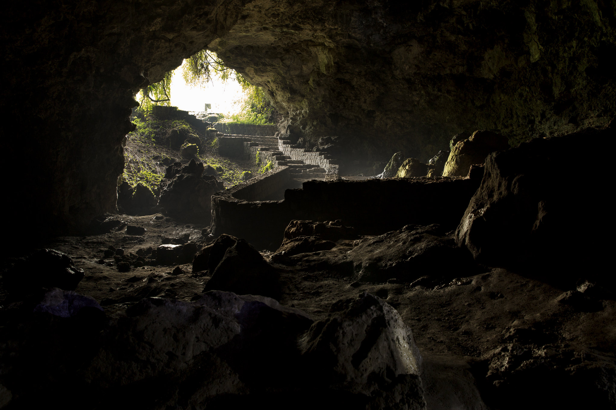
Visit Musanze Caves in Rwanda, located near Volcanoes National Park, to explore a historic 2-kilometer-long lava tunnel formed over centuries. These caves are a popular addition to Rwanda safaris and offer an intriguing underground adventure. Often paired with gorilla trekking in Rwanda, the caves feature 31 entrances surrounded by picturesque landscapes. Guided tours provide visitors with helmets, flashlights, and insights into the geological and cultural significance of the site. The experience combines nature, history, and unique biodiversity, making it a must-see destination for tourists exploring northern Rwanda.
What are the Musanze Caves, and where are they located?
The Musanze Caves are a system of volcanic underground caves located in the Northern Province of Rwanda, near the town of Musanze (formerly Ruhengeri). These caves span approximately 2 kilometers in length and are known for their stunning natural formations, historical significance, and importance to local culture.
Musanze town itself lies near the Volcanoes National Park, which is famous for being home to endangered mountain gorillas. Being situated in such a geologically rich region, the Musanze Caves are thought to have formed as a result of past volcanic activity associated with the Virunga Volcanoes.
Rwanda has worked to preserve and make the caves accessible to visitors by developing safe pathways and guided tours. Visitors can easily locate the caves just outside Musanze town, making them a popular spot for both locals and international travelers.
What is the historical and cultural significance of the Musanze Caves?
The Musanze Caves hold deep historical and cultural value for the local community. Historically, these caves were used as a shelter during times of conflict or natural disasters. Because they are large and span a significant area underground, they provided safety and protection for entire groups of people.
In ancient times, the caves were considered a sacred space, and they often played an essential role in traditional ceremonies and rituals. As such, they are deeply connected to the traditional beliefs and lifestyles of the local population.
During the colonial and later the post-independence period, the caves remained a notable feature in the Northern Province. Over time, they transitioned from being primarily functional to a tourist attraction.
Today, efforts have been made to preserve their natural beauty and educate visitors about their relevance through guided tours.
How were the Musanze Caves formed, and what is their geological background?
The Musanze Caves were formed as part of the volcanic activity in the Virunga region. The area around Musanze is dominated by the Virunga Volcanoes, which are a chain of volcanic mountains that include volcanoes like Mount Bisoke and Mount Karisimbi. During ancient eruptions, lava flowed across the landscape, and as it cooled, some sections solidified into rock while others created hollow spaces beneath the surface – these hollows formed the caves.
Over thousands of years, the caves became more defined as tectonic forces and natural erosion shaped their structure. Inside, visitors can see stalactites and stalagmites, which form when minerals dissolve in water dripping through the cave ceiling and floor.
This geological background makes the Musanze Caves a notable example of the effects of both volcanic and erosional processes. Their structure and size highlight the interaction of natural forces over long spans of time. The caves’ volcanic origin also connects them to the tectonic activity of the East African Rift.
Visitors today can explore this geological heritage with designated pathways and lighting to safely display the beauty of these underground formations.
What can visitors expect to see and experience inside the Musanze Caves?
Visitors to the Musanze Caves in Rwanda will encounter a unique underground environment shaped by volcanic activity thousands of years ago. These caves stretch for 2 kilometers and contain twisty tunnels, impressive rock formations, and spacious chambers. The caves are part of the larger volcanic region surrounding the Virunga mountain range, and their appearance reflects this geological history.
Inside, visitors will notice lava rock layers forming the walls and floors, and the occasional streaks of mineral deposits make the surfaces shiny and colorful. The layout varies between narrow passages and wide-open chambers, some of which are large enough to feel like underground halls. A standout feature is the ceiling openings, which allow shafts of light to filter in, creating dramatic effects and helping visitors navigate.
Evidence of the caves’ long history includes old sites where ancient Rwandans once sought shelter and used the caves during wartime. Bats are the most common inhabitants, and visitors might see groups of them hanging from the ceilings. The guides often explain both geological facts and cultural tales tied to these caves, making every visit a mix of learning and exploration.
The caves have been developed for tourists, with walkways and stairs installed in some areas to improve access. Visitors will feel like they’ve stepped into another world that’s both ancient and intriguing. Flashlights and proper footwear are essential during the guided tours because it’s quite dark despite the occasional natural light breaks.
Are there guided tours available for exploring the Musanze Caves?
Yes, there are guided tours available for exploring the Musanze Caves, and they are highly recommended for a safe and informative experience. The Rwanda Development Board (RDB) organizes many of these tours, ensuring that visitors are accompanied by professionals familiar with the caves’ history, structure, and safety protocols.
Guides provide visitors with flashlights and helmets for protection while giving valuable commentary on the volcanic origins, cultural significance, and biodiversity of the caves. They also manage group movements, ensuring everyone stays on the marked paths and avoids the more unstable or unsafe parts of the caves.
The tours are structured to cater to both groups and individuals with varying skill levels, making them suitable for anyone, from beginners to those comfortable with caving adventures. During the tour, guides will point out specific landmarks, such as mineral deposits and special features like skylights or chambers with historical relevance. Some guides even share stories about how the caves were used during past conflicts as shelters, adding depth to the visit.
These tours typically last between one to two hours, depending on the group’s pace and interests. Booking through authorized organizations or directly through the tourism offices in the town of Musanze ensures visitors have a safe and enriching experience while exploring the caves.
What is the best time of year to visit the Musanze Caves?
The best time to visit the Musanze Caves is during the dry seasons in Rwanda, which occur from June to September and again from December to February. During these months, the weather is generally more predictable, with less rainfall and drier trails leading to and around the caves.
Rainy seasons in Rwanda, from March to May and October to November, can make visits more challenging. Heavy rain can make the ground outside the caves muddy and slippery, and though the caves themselves don’t flood easily, the surrounding environment might become less accessible. Visitors might also feel less comfortable exploring during wet conditions due to the increased possibility of slipping on rocks.
The dry seasons are also the peak times for tourism in Rwanda, meaning the facilities around the caves, like guides and transportation services, are more readily available. While this may mean slightly busier tours, it ensures a better overall experience. For those interested in combining their cave visit with other outdoor activities in the nearby Volcanoes National Park, like gorilla trekking, the dry season is particularly convenient.
Morning tours during this period are especially favorable due to cooler weather and less crowding. Visitors should aim to book in advance if traveling during high-demand months, as accommodations and tours around Musanze can fill up quickly.
How long does a typical tour of the Musanze Caves last?
A tour of the Musanze Caves typically lasts 1-2 hours, depending on various factors like the group’s pace and interest in exploring specific areas. The caves extend for about 2 kilometers, and the tour usually follows a designated walking route that highlights the most interesting parts, such as the impressive lava formations, large chambers, and natural skylights. Guides often pause to provide information about the cave’s history, unique features, and the formation process, so the pace can vary based on how engaged the group is with the explanations.
For visitors with mobility constraints or those traveling in larger groups, tours might take slightly longer to ensure everyone has time to explore comfortably. The duration also depends on how much time is spent taking photos or simply enjoying the unique features of the cave environment. It’s worth noting that some portions of the path might be uneven or slightly slippery due to the nature of the volcanic rocks, but this is a manageable part of the tour for most visitors.
The tour duration is designed to give people enough time to explore without feeling rushed. If visitors wish to spend additional time taking in the surroundings outside the caves, such as the nearby vegetation or scenic views, this could extend their overall visit, though the cave-specific tour is usually completed within 2 hours.
What safety precautions should visitors take when exploring the caves?
When going to the Musanze Caves, wearing the proper gear is very important for safety. The ground is often uneven, has loose stones, or may be wet, so visitors are advised to wear sturdy closed-toe shoes with good grip, like hiking boots. Protective helmets are often provided by the tour organizers to guard against head injuries in the event of slipping or bumping into the low ceilings or cave walls.
Additionally, the caves can be dark, so flashlights or headlamps are used to ensure visibility. Many tour operators supply these, but it’s always good to ask ahead if visitors have concerns. It is equally important to stick to the designated pathways marked by the guides. Wandering off can be dangerous, as certain sections might be unstable or difficult to navigate.
For personal safety, individuals should not enter the caves alone. Guided tours not only enhance the experience with knowledge but also ensure that visitors are aware of the safer areas of the caves to see. People are encouraged to follow the tour guide’s instructions closely at all times.
Lastly, visitors should bring a bottle of water for hydration but avoid carrying large bags, as the confined spaces in some areas make it impractical. People with severe claustrophobia or breathing issues should take into account the confined atmosphere inside the caves and consult with the tour operator beforehand.
Are there any special permits or entrance fees required to visit the Musanze Caves?
Yes, visitors to the Musanze Caves are required to pay an entrance fee. This cost is usually handled through the Rwanda Development Board (RDB) or similar authorized institutions involved in tourism management. Fees may vary depending on whether the visitor is a Rwandan citizen, an East African Community (EAC) resident, or an international tourist. For instance, international visitors generally pay a higher fee compared to local or regional tourists.
As of recent years, the entrance fee often includes services such as guided tours and required safety gear like helmets. Therefore, tourists generally don’t need to arrange special permits in advance unless they are part of a large group tour needing special arrangements.
It’s wise to check with local tour operators or the RDB for the most accurate and updated pricing prior to the visit. Many visitors opt to book packages that include transportation, which makes entry smoother and eliminates the need to handle fees separately. Payment is usually straightforward, either made online or at the entrance site in cash or card.
For people traveling independently, ensuring they have the correct identification (like passports or EAC IDs) can help clarify the fee category they fall into. Recognizing this cost ahead of time allows visitors to prepare better for their trip.
What are some nearby attractions or activities that can complement a trip to the Musanze Caves?
The Musanze area is surrounded by several well-known attractions and activities that make it an exciting destination for visitors not only interested in the caves but also looking to explore Rwanda’s offerings. Volcanoes National Park, just a short distance from the caves, is one of the most popular locations. This park is famous for being home to the endangered mountain gorillas, and tourists can book guided treks to see these majestic primates in their natural habitat. It’s a once-in-a-lifetime experience for wildlife enthusiasts.
Mount Karisimbi, one of the volcanoes in the region, is also nearby. Adventurous visitors can take on the challenge of hiking to its summit over two days. For a shorter adventure, trekking Mount Bisoke offers a chance to see beautiful views and a crater lake at its peak.
For visitors who prefer a more relaxed activity, the nearby lakes in the region, such as Lake Ruhondo and Lake Burera, provide scenic spots for birdwatching, boat rides, and enjoying nature. These lakes are surrounded by hills and give a peaceful, picturesque vibe.
In addition, cultural experiences, like visiting the Iby’Iwacu Cultural Village, allow visitors to learn about Rwandan traditions, dance, and local crafts. Lastly, exploring the nearby town of Musanze itself can be interesting, offering local restaurants and markets where tourists can taste Rwandan cuisine and buy souvenirs.
Whether you’re into wildlife, hiking, or cultural exploration, these options make the area around Musanze Caves a well-rounded destination.
What kind of wildlife or unique fauna can be found around the Musanze Caves?
The region surrounding the Musanze Caves is rich in biodiversity due to its location near Volcanoes National Park, home to many unique and rare species. The most famous residents are the mountain gorillas, which inhabit the dense forests of the park. These primates are a major reason why many people travel to this area of Rwanda. Gorilla trekking tours operate in the park, offering an opportunity to observe them up close in their natural habitat.
Beyond gorillas, visitors might also encounter golden monkeys, another rare primate species native to the area. These monkeys have golden-orange fur and are often found in the bamboo forests around the national park.
In terms of bird species, the region is a haven for birdwatchers. Many types of birds, including the Ruwenzori turaco with its beautiful green and blue feathers, can be spotted here.
The forest also hosts small mammals, like forest antelopes and hyraxes, although you might not always see these creatures as they are more elusive. Various insects, reptiles, and amphibians native to the volcanic terrain also add to the area’s uniqueness, though these might only be noticed by visitors with a sharp eye.
While inside or near the caves themselves, you might see bats, as they are common in such environments. The caves provide a natural home for them, so visitors may notice the sound of fluttering wings or see them hanging from the cave’s ceiling. These bats play a role in maintaining the ecosystem by helping with insect population control.
For nature lovers, this region is teeming with wildlife that adds to the overall appeal.
What are the transportation options to reach the Musanze Caves from major cities in Rwanda?
Traveling to the Musanze Caves is straightforward, as the town of Musanze is a major hub in Rwanda and well-connected to other parts of the country, especially Kigali, the capital city.
For those traveling from Kigali, one of the quickest and most convenient ways to reach Musanze is by car or private transportation. The drive takes about two hours on well-paved roads and provides scenic views of the Rwandan countryside along the way. Renting a car or hiring a local driver is a common choice for travelers who prefer flexibility and comfort.
Another option is using public buses from Kigali to Musanze. Several bus companies operate this route, including Volcano Express and Horizon. These buses are affordable and reliable, departing regularly from Kigali’s main bus station. Tickets are inexpensive, and the journey typically takes about two to three hours.
For visitors already in Musanze, local moto-taxis (motorcycle taxis) or regular taxis are a practical way to get to the caves from the town center. Moto-taxis are especially popular because they are both quicker and cheaper for short distances.
For those arriving by air, Kigali International Airport is the closest major airport. After flying into Kigali, visitors can then choose any of the above options to travel to Musanze. Guided tours often include transportation as part of their package, which is convenient for tourists who want everything arranged beforehand.
Overall, whether you choose private transportation, buses, or taxis, reaching the caves is manageable, and the journey itself can be an enjoyable part of the trip.
How to Book Your Safari in Rwanda
Curious about exploring the fascinating Musanze Caves? We’ve covered the basics, including what makes these caves special, how to visit them, and why they’re a must-see for any traveler in Rwanda. Ready to experience this unique adventure firsthand? Contact one of the trusted Rwanda Safari Companies to plan your trip effortlessly. They’ll ensure every detail is covered so you can enjoy a hassle-free safari to the iconic Musanze Caves. Start planning today!
Climb Mount Nyiragongo Volcano
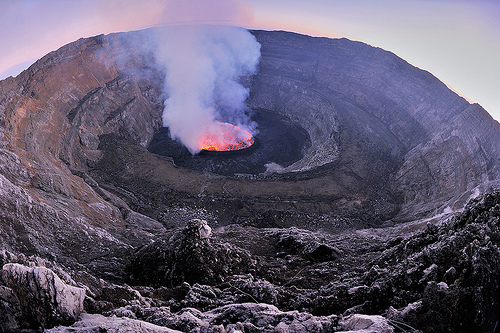
Visit Mount Nyiragongo, an active volcano in the Democratic Republic of Congo, for a hiking adventure unlike any other. Located near Volcanoes National Park, it features a breathtaking lava lake that glows at night. Many travelers combine this experience with Rwanda safaris or gorilla trekking in Rwanda, as the nearby border makes it accessible from Rwanda. The climb typically requires physical fitness and involves overnight camping at the summit. Permits are required, and tours often include guides, porters, and safety briefings. The summit views and unique volcanic activity make it a must-see for adventure enthusiasts visiting the region.
Where is Mount Nyiragongo located?
Mount Nyiragongo is found in the eastern part of the Democratic Republic of the Congo (DRC), a large country in Central Africa. Specifically, it is located within Virunga National Park, a UNESCO World Heritage Site that is home to diverse wildlife, including mountain gorillas. The mountain sits very close to the city of Goma, which lies on the northern shores of Lake Kivu and serves as a key access point for visitors heading to the volcano.
This area is part of the larger Albertine Rift, which is a segment of the East African Rift System. The mountain lies near the border between the DRC and Rwanda, and both countries share some of the natural features in this region. The proximity to Goma means that the volcano directly affects the lives of thousands of people in the surrounding communities.
For travelers, its exact coordinates are approximately 1.52° South and 29.25° East, placing it near the equator. To sum up, Mount Nyiragongo’s location in the Virunga Mountains, close to Goma and Lake Kivu, makes it an iconic geographical and geological feature of the region.
What is unique about Mount Nyiragongo compared to other volcanoes?
What makes Mount Nyiragongo stand out among volcanoes is its permanent lava lake, which is one of the few of its kind in the world. This lava lake is located inside the crater at the summit of the volcano and offers a spectacular view of molten lava churning and glowing, especially during the nighttime. Unlike typical volcanoes where lava eruptions may occur temporarily, the constant activity within Nyiragongo’s crater makes it particularly unusual.
Adding to the uniqueness is the composition of its lava, which is extremely fluid. The lava flows from Nyiragongo are rich in a mineral called melilite nephelinite, which causes the molten rock to be much less viscous than other types of lava. This high fluidity allows lava to travel very fast, up to 60 kilometers per hour (about 37 miles per hour), during an eruption. An example of this occurred during the 2002 eruption, when the fast-moving lava reached Goma city in just a few hours, covering roads and displacing many residents.
The combination of its lava lake and unusually fast-moving lava makes Nyiragongo a rare and geographically fascinating volcano. No other volcanoes on Earth exhibit this exact mix of characteristics.
Is Mount Nyiragongo an active volcano, and when was its last eruption?
Yes, Mount Nyiragongo is an active volcano. This means it still regularly releases lava, gases, and ash, and poses a potential threat to nearby regions. Over the years, Nyiragongo has had a history of frequent eruptions. Its activity is closely monitored because of the danger it poses to the nearby city of Goma and its surrounding areas.
The last major eruption occurred on May 22, 2021, when lava flowed out of cracks on the volcano’s flank, causing extensive damage. The eruption forced thousands of people to evacuate, and some sought refuge in neighboring countries like Rwanda. Lava flows came dangerously close to Goma, and although it caused significant destruction, the city center was spared.
Other significant eruptions include one in 2002, where lava flowed directly into Goma, destroying homes and infrastructure, and another in 1977, which released even faster-moving lava that claimed hundreds of lives.
Despite periods of calm, scientists consider Nyiragongo highly unpredictable and dangerous due to its tendency for sudden and dramatic eruptions. Therefore, local authorities and scientific organizations carefully monitor seismic activity and gas emissions near the volcano to provide early warnings if needed.
What safety measures should visitors take when visiting Mount Nyiragongo?
Visiting Mount Nyiragongo, a high-risk area due to its active volcano status, requires proper precautions to ensure your safety. Volcanic eruptions and the environment near the volcano can be dangerous without preparation.
First, make sure you stay informed about the current activity level of the volcano. Checking reports from volcanic monitoring organizations is crucial before planning your trip, as unexpected eruptions can occur. Discussing this with your tour operator can also provide valuable insights.
Hiring an experienced guide is critical. Local guides are familiar with the terrain, risks, and safest paths, ensuring an organized and safer hiking experience. Do not attempt a hike without a professional.
The air near the volcano can sometimes contain harmful gases such as sulfur dioxide, so staying close to your group and following your guide’s instructions is vital. These gases are especially a concern for individuals with breathing problems like asthma.
Pack for unpredictable weather conditions due to the altitude. Wear sturdy boots, a rain jacket, and thermal layers to handle the sudden drops in temperature. Also, consider bringing a flashlight or headlamp as the path may get dark during descents.
Carry enough water, snacks, and basic medical supplies, such as regular over-the-counter medications and a small first aid kit.
Always remain vigilant of the terrain, as it may include loose lava rocks and sloped paths that demand careful footing. Keep a fair distance from lava lakes or steam vents on the summit to avoid any injuries.
Lastly, register your visit with local authorities or rangers. Following these safety measures ensures a more controlled and better-prepared experience around Mount Nyiragongo.
How can one access Mount Nyiragongo (transportation and permits required)?
Mount Nyiragongo is located within Virunga National Park, in the Democratic Republic of Congo (DRC). Getting there involves careful planning due to permits, transportation logistics, and access coordination.
To begin, you will need a Congolese visa to enter the DRC. In addition to the visa, a hiking permit for Mount Nyiragongo is mandatory to trek the volcano. These permits are available online or through tour operators and are issued by Virunga National Park authorities.
Most travelers reach Mount Nyiragongo via Goma, the closest city to the park. From Kigali in Rwanda, Goma is accessible by road or a short domestic flight. Many visitors fly into Kigali International Airport, then travel by road to the Rwanda-DRC border at Gisenyi. After crossing the border, it is about 20 minutes by car to Goma.
Once in Goma, you can proceed toward the Kibati Ranger Station, the starting point for the hike up Nyiragongo. Pre-arranged private transport or tour company vehicles are the most common means of getting there from Goma.
When booking transportation, consider hiring reputable services. Public transport isn’t recommended for safety and convenience reasons. Organized group tours simplify this whole process, as they often include all permits, guides, and transfers in their packages.
Checkpoint procedures near the volcano can be lengthy, so it’s recommended to leave ample time to complete the border crossing, permit registration, and entry.
Making these plans ahead of time ensures smoother travel to the volcano. Hiring licensed operators and confirming your permits weeks in advance is crucial.
What is the best time of year to visit Mount Nyiragongo?
The best time to visit Mount Nyiragongo is during the dry seasons, which typically occur twice a year. The weather during these months is more favorable for hiking and outdoor activities compared to the rainy seasons.
The first dry season usually runs from mid-December to February, and the second dry season from June to early September. During this time, there is less rain, making the trails safer and more accessible. This is important as heavy rain can make the trails muddy, slippery, and harder to navigate.
Views are also clearer in the dry seasons. Hikers climbing Mount Nyiragongo during this time are more likely to get stunning views of the lava lake at the crater. In contrast, rainy conditions might reduce visibility and obstruct the sights.
Another reason to visit in the dry season is that it’s easier to find guided treks and arrange transport. Many tourists plan their trips for these months, so there is more availability, and the park services are more active with guides and infrastructure.
Although the dry season is recommended, visiting requires warm clothing no matter the time of year, as the temperature drops significantly at higher altitudes, especially at the summit.
Finally, always check the weather forecast before deciding on your trek date, as conditions can vary slightly. By planning your trip during these months, you can have a safer and more pleasant hiking experience.
What kind of physical fitness or preparation is needed to hike Mount Nyiragongo?
Hiking Mount Nyiragongo requires moderate to good physical fitness because it can be challenging for those who are not prepared. The trail is steep in many sections, with an elevation gain of about 1,500 meters (approximately 4,900 feet) from the starting point to the summit. It’s important to be both physically and mentally ready for several hours of continuous uphill trekking.
To prepare, it’s ideal to engage in regular cardio exercises such as jogging, cycling, swimming, or walking uphill a few weeks before your trek. This will help you build stamina for the journey. Strength-training workouts can also improve your leg muscles, making the steep ascent easier to manage.
Another thing to consider is altitude. The summit of Mount Nyiragongo, at 3,470 meters (11,384 feet), means you might feel the effects of thinner air, which could lead to difficulty in breathing or mild symptoms of altitude sickness. Practices like hiking smaller elevations beforehand can help your body adjust. Drinking enough water and pacing yourself during the ascent also help in reducing the risk of altitude sickness.
It’s not uncommon for people to feel tired or sore, so mentally preparing to take steady, deliberate steps rather than rushing is key. A slow, consistent pace and breaks along the way will help reserve your energy for the longer sections of the hike.
Parents planning to bring their children (especially older ones) should ensure the kids are accustomed to walking long distances and have the physical strength to manage the trail.
Group trekking with guides is mandatory as they provide extra assistance, encouragement, and help manage the pace for all skill levels.
How long does it take to complete a Mount Nyiragongo trek?
The entire trek to Mount Nyiragongo’s summit and back generally takes two days. On the first day, you’ll trek from the base (starting at the Kibati Ranger Station) to the summit, which usually takes around 4 to 6 hours, depending on your fitness level and pace. The path is about 8 kilometers (5 miles) long, but because it’s steep, it becomes slower and more demanding as you get higher.
The ascent is typically done in stages, with several breaks along the way. Many groups aim to reach the summit by late afternoon to get enough time to rest, take in the glowing lava lake, and enjoy the incredible views before nightfall.
Once you reach the summit, most hikers spend the night in basic shelters at the top. This overnight stay is necessary for most treks as returning down the mountain immediately after reaching the summit could be too exhausting, especially if you’re not used to steep hikes.
The descent happens on the second day and takes about 3 to 4 hours, as going downhill is quicker. However, it can still be demanding on the knees and ankles, so good footwear and trekking poles are essential.
To summarize the timeframe: day one is about half a day to hike to the summit, and day two is a few hours climbing back down. Though the journey is fairly short in terms of distance, the terrain and elevation make it more of a slow and steady trek rather than a simple walk.
What are the sights and experiences to expect during the trek to Mount Nyiragongo?
During the trek to Mount Nyiragongo, there’s a variety of beautiful scenery and unique experiences for hikers to enjoy.
The starting point at Kibati Ranger Station introduces you to lush greenery and a trail surrounded by dense tropical forests. As you climb higher, the environment begins to change, with the forest eventually giving way to more rugged and volcanic terrain.
One of the most striking features is the black volcanic rock that dominates the path. It serves as a reminder of the mountain’s powerful eruptions in the past. You might also come across patches of vegetation clinging to the volcanic rock, such as wildflowers that add a pop of color to the otherwise dark landscape.
As you climb, it’s common to see local wildlife, including small mammals, birds, and unique insects. Guides often point out interesting flora or fauna native to the region.
When you finally reach the summit, the view of the active lava lake is breathtaking. The molten lava’s bright red and orange glow, combined with the distant rumbling and occasional spurts of lava, is a rare sight that leaves a lasting impression. On clear days, the summit also offers sweeping views of the surrounding Virunga National Park, neighboring valleys, and even other nearby volcanoes.
At night, the glowing lake is even more vivid and provides a mesmerizing light show. Starry skies above and the peaceful quiet of the summit make for a one-of-a-kind camping experience.
The descent offers a second chance to enjoy the scenery from a different perspective, seeing how the volcanic landscape blends with the surrounding forested areas.
All in all, the trek combines a rugged natural setting, evolving terrain, and the unforgettable sight of the volcanic summit, leaving hikers with a profound appreciation for this unique part of nature.
What gear, clothing, and supplies are essential for the Mount Nyiragongo hike?
When planning to hike Mount Nyiragongo, preparation is crucial, as the terrain, weather, and altitude can be challenging. Here’s a breakdown of what you’ll need to bring for a safe and comfortable experience:
- Footwear: A sturdy pair of hiking boots with strong grip and ankle support is a must. Sneakers or basic walking shoes won’t provide the needed protection against the rocky paths and volcanic terrain.
- Clothing Layers: The weather can change quickly. Start with moisture-wicking base layers to keep sweat off your skin. Add a warm fleece or down jacket for higher altitudes where temperatures drop. On top of that, a waterproof and windproof jacket is important if it rains or winds pick up.
- Hiking Pants over shorts are better for protecting your legs from scratches on the rough paths. Waterproof pants may come in handy.
- Hat and Gloves: As the summit can get very cold, you’ll need warm gloves and a hat or beanie to shield you from the cold.
- Lighting: A headlamp or flashlight is essential, as many trekkers reach the summit around dusk or early morning when visibility is low.
- Sleeping Bag: If spending the night in the summit huts, carry a high-quality, insulated sleeping bag appropriate for cold temperatures.
- Food and Snacks: While the hike is guided, you should pack high-energy snacks like nuts, dried fruits, energy bars, and possibly instant food for energy throughout the trek.
- Hydration: Carry at least 3 liters of water per day. Rehydration salts or tablets are great for replenishing electrolytes.
- Walking Stick or Trekking Poles: These can greatly reduce strain on your knees and provide added balance on uneven terrain.
- First Aid Kit: Include band-aids, anti-inflammatory medications, altitude sickness medication, and any personal medicines.
- Backpack: A comfortable, durable backpack to carry your supplies is key. Look for one with padded straps and compartments to organize your items.
- Miscellaneous Gear: Bring sunscreen, sunglasses to protect your eyes, a rain cover for your bag, bug repellent, and lip balm with SPF.
The right gear makes the hike more manageable, ensuring comfort and safety throughout the experience. Always double-check what’s recommended by your guide service as conditions may vary.
Are there any accommodation options near or on Mount Nyiragongo?
Yes, there are accommodations near Mount Nyiragongo and some at the summit for hikers. Here’s a breakdown:
- Huts on the Summit: At the top of Mount Nyiragongo, there are rustic shelters provided. These are simple wooden huts with no heating but offer basic protection from the wind and cold. You’ll need to carry your sleeping bag and possibly padding for extra comfort, as the facilities are minimal. These accommodations allow you to spend the night near the lava lake, a rare experience.
- Lodges and Hotels in Goma: The city of Goma, located at the base of Mount Nyiragongo, has a range of accommodation options. Prices and quality vary, though you’ll find mid-range hotels and budget lodges. Some examples include Kivu Lodge, IHUSI Hotel, and Sleep Inn Goma. These are convenient for rest before and after the trek.
- Tented Camps: Some eco-lodges and campsites offer tented accommodations closer to the Virunga National Park, where Mount Nyiragongo is located. These options often attract travelers looking for scenic, nature-driven experiences.
- Virunga Lodges: If travelers are exploring the wider Virunga region, they might consider staying at one of the lodges affiliated with the national park, such as Mikeno Lodge, which provides more luxurious stays along with park access.
Keep in mind that staying overnight in these areas typically requires park permits. Booking accommodations in advance, especially during peak trekking seasons, is highly recommended.
What cultural or regional highlights can travelers explore near Mount Nyiragongo?
Travelers near Mount Nyiragongo can enjoy exploring the rich cultural and natural offerings of the Virunga region and surrounding areas in the Democratic Republic of Congo (DRC). Here are some highlights:
- Virunga National Park: This UNESCO World Heritage Site is not only home to Mount Nyiragongo but is also famous for its diverse wildlife, including the endangered mountain gorillas. Gorilla trekking is one of the most sought-after activities, offering visitors a chance to observe these animals up close in their natural habitat.
- Lake Kivu: This large freshwater lake is located near Goma and provides beautiful scenic spots, boat rides, and opportunities to relax by the water. The lake is also shared with neighboring Rwanda.
- Local Markets in Goma: The city of Goma offers bustling local markets where visitors can engage with the Congolese culture. Markets sell everything from fresh food to traditional crafts.
- Congolese Cuisine: Travelers can sample local dishes like pondu (cassava leaves), sambaza (fried fish from Lake Kivu), and fufu, which is a staple made from cassava flour. Restaurants in and around Goma serve traditional meals.
- Cultural Music and Dance: Traditional music and dance performances can occasionally be found in the region. Engaging with this aspect of Congolese culture offers insight into local traditions.
- Adjacent Countries: Goma shares a border with Rwanda, making it easy to visit places like Musanze for gorilla trekking on the Rwandan side or other Rwandan attractions.
- Mount Nyamuragira: This nearby volcano is one of the most active in the world and sometimes erupts simultaneously with Nyiragongo. For those interested in geology or adventure, this could be another stop.
- Humanitarian Efforts and History: Goma and the surrounding areas have historically faced conflict and instability. While sobering, travelers can learn about the region’s challenges through visits to local organizations or museums documenting its history and resilience.
Exploring cultural and natural landmarks provides a deeper understanding of the DRC’s rich heritage and vibrant surroundings.
How To Book Your Safari in Rwanda
Curious about visiting Mount Nyiragongo? We’ve covered the essentials, from what makes this volcano so intriguing to why it’s worth the trip and how to get started. Ready to experience its breathtaking views and magical lava lake up close? Make it happen with ease by reaching out to Rwanda Safari Companies. They’ll help plan your adventure and ensure a seamless journey to this wonder. Don’t wait, start planning your unforgettable safari today!
Mount Bisoke Rwanda
The Bisoke hike in Rwanda is a popular activity within Volcanoes National Park, known for its stunning crater lake at the summit. Mount Bisoke, an active volcano standing at 3,711 meters, offers a challenging yet rewarding trek that takes approximately 6 hours round trip. This hike is part of many Rwanda safaris and is often combined with activities like gorilla trekking in Rwanda. The trail features diverse landscapes, from lush forests to steep volcanic terrain, making it an excellent choice for adventure seekers. A guide through the park ensures safety and provides insights into the mountain’s ecology and history. Hiking permits can be obtained through the Rwanda Development Board, and good physical fitness is recommended.
What is Mount Bisoke and where is it located in Rwanda?
Mount Bisoke is a stratovolcano situated in the Virunga Mountain range in Rwanda. It is part of an area known for its chain of volcanoes straddling the borders of Rwanda, Uganda, and the Democratic Republic of Congo (DRC).
This mountain is located in the Volcanoes National Park, which is in the northwestern part of Rwanda. Volcanoes National Park is also famous globally as the habitat of the endangered mountain gorillas. Mount Bisoke is unique as it offers impressive natural features, such as a crater lake near its summit.
Mount Bisoke lies close to the border with Congo, and while its base is in Rwanda, the mountain’s caldera overlaps slightly into Congo. It is one of the several volcanoes in the region, but it stands out for being an active volcano, although its last eruption occurred in 1957.
The region surrounding Mount Bisoke is rich in biodiversity, with dense rainforest, bamboo forests, and alpine meadows covering it. This makes it not only a significant geological site but also a hotspot for eco-tourism in the Rwandan hills.
How challenging is the Bisoke hike and how fit should one be to attempt it?
The Bisoke hike is often described as moderately difficult. While it doesn’t require technical climbing skills, it does demand a fair level of physical fitness and stamina. This is due to the steep slopes, muddy pathways, and the high altitude, which can make breathing a little harder for some hikers.
The hike begins at an altitude of around 2,700 meters (8,850 feet) above sea level and climbs up to the summit at 3,711 meters (12,175 feet). This involves a steep vertical climb of more than 1,000 meters (over 3,000 feet), which can be tiring for people who are not used to hiking or physical activity.
The trail can often be slippery and muddy, especially during or after the rainy season. Parts of the path can have uneven surfaces with rocks or tree roots. Because of this, hikers may need to use a hiking stick, which is typically provided.
People with moderate fitness levels, such as those who exercise or walk regularly, can generally complete the hike, but it might feel strenuous at times. Someone who leads a very inactive or sedentary lifestyle can find the hike too demanding.
Frequent breaks on the trail and walking at a steady pace are typically encouraged. Porters are also available for hire to carry bags or provide assistance. Some hikers suggest doing shorter treks or cardio exercises beforehand to prepare.
What is the elevation of Mount Bisoke and its crater lake?
The summit of Mount Bisoke reaches an elevation of 3,711 meters (12,175 feet) above sea level. It is one of the higher peaks in the Virunga Mountain range.
A distinctive feature of Mount Bisoke is its beautiful crater lake, found near the summit, giving the hike added uniqueness. The lake sits at an altitude just slightly below the mountain’s apex. While an exact measurement for the lake’s elevation is often lumped in with the summit height, it is generally within a few meters of the 3,711 meters (12,175 feet) mark.
This crater lake was formed as a result of volcanic activity, specifically from a past eruption that left a water-filled depression at the top of the volcano. The lake is known for its striking circular shape and still waters, which remain untouched in the remote, high-altitude environment.
The high elevation means that the weather around the summit can be cool or cold, and hikers often notice a thinner air supply due to lower oxygen levels. These factors, combined with the majestic views of the lake and surrounding landscape, make summiting Mount Bisoke a rewarding experience for trekkers.
How long does the hike typically take to complete?
The Mount Bisoke hike usually takes about 4 to 6 hours in total, depending on a person’s fitness level, the weather conditions, and the pace of the group. The hike is divided into two parts: ascending to the summit and descending back to the starting point.
For most hikers, the ascent to the summit takes between 2.5 to 4 hours. This part of the hike is mostly uphill, with steeper sections requiring proper footing, especially if the ground is muddy. Along the way, you may need to take breaks to rest and catch your breath, particularly as the elevation increases and the air becomes thinner.
The descent, which is generally faster, might take about 1.5 to 2 hours. It is less physically demanding but can still be challenging in wet weather as the ground might be slippery. This is especially true after rain, which is common in the area.
Factors like group dynamics, weather, and individual stamina play a role in how long it will ultimately take. For instance, a group traveling with older adults or less experienced hikers might take longer, while a group of physically fit individuals may complete the hike faster.
Example for Context:
Imagine you start your hike at 7:00 AM, and your group moves at an average pace. You might reach the summit around 10:30 AM and spend 30 minutes enjoying the views of the crater lake before heading back down. By 1:00 PM, you’re likely back at the trailhead, ready to conclude your adventure.
Key Tip: Start early in the day to give yourself enough time to complete the hike and avoid bad weather, which often develops in the afternoon.
What is the best time of year to hike Mount Bisoke?
The ideal time to hike Mount Bisoke is during Rwanda’s dry seasons, which occur twice a year:
- Mid-December to early February, and
- June to early September.
During these periods, the weather is much more favorable for hiking. Trails tend to be drier and less slippery, making the ascent and descent less challenging. While the trails are located in a humid region (since the mountain is part of the tropical rainforest), dry seasons significantly reduce the likelihood of heavy rains that might turn trails into muddy pathways.
The wet seasons, typically March to May and October to November, bring heavy rains that can make hiking more difficult and potentially unsafe. The mud and waterlogging caused by these rains can make the trail slippery, slow hikers down, or even create conditions where the trail becomes impassable.
Even during the dry season, keep in mind that Mount Bisoke is located in a rainforest zone, and short rain showers are still possible. Having the right footwear and waterproof clothing can prevent discomfort if a sudden drizzle occurs.
Example for Context:
Let’s say you plan to hike in July. You can expect trails that are easier to navigate due to reduced rainfall, improved visibility at the summit, and overall more predictable conditions.
Key Tip: A clear sky not only makes hiking safer but also offers better views of the crater lake and surrounding environment. Always check weather reports before your hike to pick the most favorable day.
Do you need a guide or permit to hike Mount Bisoke?
Yes, you need both a guide and a permit to hike Mount Bisoke. The mountain is located in Volcanoes National Park, and the park requires all hikers to obtain permits as part of their conservation efforts.
Permit Information:
The permit is issued by the Rwanda Development Board (RDB) and costs approximately $75 USD per person (as of 2023). This fee includes the services of a professional guide provided by the park. You cannot hike Mount Bisoke independently; the guide is required to ensure the safety of all hikers and to prevent environmental damage.
Without a permit, you wouldn’t be allowed to start the trek. Your permit covers important logistics, such as ranger-led tours, guiding services, and sometimes essential security measures to protect hikers from wildlife encounters or other risks.
Role of a Guide:
The guide will not only lead the way but will also share valuable information about the flora, fauna, and geology of the region. They are experienced in navigating the trail, especially in case of challenges like bad weather or muddy conditions. In addition to the guide, an armed park ranger usually accompanies hikers to ensure protection from wildlife.
Example for Context:
Let’s imagine you arrive at the park without prior arrangements. You would need to visit the park office, pay the permit fee, and join a group led by a guide. The park organizes daily treks, so joining a group is straightforward.
Key Tip: It’s advisable to book permits in advance, especially during the peak dry seasons, as slots can fill up quickly. Bring your identification and payment when purchasing your permit.
What kind of wildlife or vegetation can you encounter during the hike?
On Mount Bisoke, located in Volcanoes National Park in Rwanda, hikers can expect a variety of wildlife and vegetation due to the mountain’s location within a biodiverse region. The mountain is part of the wider Virunga Mountains, which are known for their rich ecosystems.
One of the highlights for many visitors is the chance to see mountain gorillas, though sightings are typically rare during the hike itself. These gorillas inhabit the park’s dense forests. Other primates, such as golden monkeys, might also be spotted along the trail. Birdwatchers will notice a variety of bird species since the region is home to a large number of forest-dwelling birds, with some being endemic to the area.
The vegetation changes as you ascend the mountain. Lower altitudes feature lush tropical rainforests, filled with tall trees intertwined with vines and other undergrowth. These areas are home to small mammals, insects, and a wide array of plant life. As you climb higher, the vegetation gradually transitions into bamboo forests, which serve as a habitat for certain primates like the golden monkey. At even higher altitudes, you’ll find alpine meadows and moorlands, with smaller shrubs and plants adapted to the cooler, harsher conditions.
Hikers may also notice various species of flowering plants, including the giant lobelia and giant groundsel, which are unique to higher altitudes in East Africa. These plants are specially adapted to survive in low temperatures and thin air.
Encounters with larger animals, such as bushbucks or buffalo, are less common, but park guides accompany hikers for safety due to the possibility of these animals being in the area.
What equipment or gear is necessary for a safe and comfortable hike?
To be prepared for the Mount Bisoke hike, which can take around 4 to 7 hours depending on pace and weather conditions, having the right equipment and gear is essential for a safe and comfortable experience.
Firstly, hiking boots with good grip are a must. The trails can be steep, rocky, and muddy, especially during the rainy season. Footwear that offers ankle support will help prevent injuries. Comfortable, moisture-wicking clothing is recommended to stay dry and avoid discomfort from sweat. Layers are essential because the temperature varies as you ascend. At the summit, the air is cooler, so carrying a light jacket or windbreaker is helpful.
A daypack is useful for carrying water, snacks, and personal items. It’s vital to stay hydrated, so bring enough water bottles or a hydration pack. Quick energy snacks like nuts, trail mix, or energy bars can help maintain energy levels during the trek. Don’t forget to carry a raincoat or poncho, as the weather in rainforest areas can change suddenly.
For protection against the sun, sunscreen, sunglasses, and a lightweight hat are advisable. It’s also a good idea to bring insect repellent, as there are insects in some forested areas. Gaiters can be helpful to keep mud or small rocks out of your shoes.
Trekking poles can provide extra stability on slippery or uneven terrain. Some hikers also prefer to bring a first aid kit with essentials like bandages, pain relievers, and antiseptic wipes for minor injuries. A camera or smartphone with adequate storage and battery power is useful for capturing the stunning natural surroundings.
Lastly, lightweight gloves and a hat are good additions for the summit, as higher altitudes can feel cold even on warm days.
Are there any safety concerns or risks involved in the hike?
The Mount Bisoke hike, while rewarding, does come with certain safety concerns and risks that hikers should be aware of. These risks primarily stem from the terrain, wildlife, and the physical demands of the climb.
Firstly, the trail conditions can be challenging. The ascent is steep and can become slippery and muddy, especially during the rainy season. Slippery surfaces increase the risk of falls or minor injuries like sprained ankles. Wearing the right footwear and taking breaks as needed can minimize these risks. Trekking poles can also provide additional stability.
Another concern is the altitude. Mount Bisoke stands at an elevation of 3,711 meters (12,175 feet), so some individuals may experience mild altitude-related symptoms such as shortness of breath, dizziness, or fatigue. Drinking water, pacing yourself, and acclimatizing before the hike can help reduce this risk.
Wildlife, while a highlight of the hike, also presents potential safety risks. Hikers are trekking in a protected area home to large animals like buffalo and, occasionally, other wildlife that could pose a danger if threatened. This is why hikers are required to have a guide with them at all times. Guides are trained to handle wildlife encounters safely and ensure hikers follow proper protocols.
Weather conditions are another factor to consider. Sudden rain can make trails slippery and affect visibility. Hikers should be prepared with waterproof gear and follow their guide’s instructions if the conditions worsen during the trek.
Lastly, physical fitness is important. The hike is strenuous and requires stamina, so those who have medical conditions or aren’t accustomed to physical activity should evaluate their capacity before attempting it. Listening to one’s body and taking breaks can reduce exhaustion or overexertion.
How much does it cost to hike Mount Bisoke, including permits and guides?
The cost to hike Mount Bisoke mainly depends on the fees required for permits and guide services, which are governed by the Rwanda Development Board (RDB). As of recent estimates, the permit fee for a one-day hike up Mount Bisoke is $75 USD per person. This is a standard fee covering access to the mountain trails and conservation efforts for the Volcanoes National Park, where the mountain is located.
In addition to the permit fee, every hiker is required to have a guide during the hike. The guide ensures safety, provides information about the environment, and leads the group along the designated paths. The cost of the guide is generally included in the permit fee, so there is no need to pay separately.
For those who feel they may need help carrying bags or supplies during the hike, porters are available for hire at the base. Hiring a porter typically costs $10–$15 USD per porter. This can be highly useful, as the hike can be physically taxing, and offloading extra weight allows hikers to focus on the trail.
If you are traveling from Kigali (the capital of Rwanda) to the base of Mount Bisoke, you should also plan for transportation costs. Hiring a private car or taxi for the 2-3 hour drive could cost $100–$150 USD round trip, depending on negotiation and vehicle type.
Overall, the total cost for a single hiker, including the permit, guide, porter (optional), and transportation, might range between $85–$250 USD or more, depending on additional services or group size. It’s advised to carry cash in Rwandan Francs (RWF) or USD for any services not included in pre-booked arrangements.
Always check with the Rwanda Development Board or a reliable tour operator for the latest fees and requirements before planning your trip.
What kind of views or scenery can hikers expect at the summit and along the trail?
Hikers on Mount Bisoke can look forward to breathtaking scenery both along the trail and at the summit. This dormant volcanic mountain, part of the Virunga Mountain Range, is covered in lush greenery, unique plant species, and dramatic landscapes.
As you ascend the trail, you’ll pass through a variety of climatic vegetation zones, beginning with dense, tropical rainforests. In this lower portion of the hike, hikers can see towering trees, ferns, and moss-covered rocks. The forest is often alive with the sounds of birds, insects, and possibly even primates like monkeys and gorillas, although the latter are rare to spot on this trek.
Further up, the landscape changes as hikers enter the bamboo forest zone, which is home to several large mammals, including gorillas and elephants. The bamboo forest features open spaces that allow a bit more sunlight to filter through, adding to the atmosphere.
The trail eventually leads into higher-altitude vegetation zones with alpine meadows and plants like giant lobelias and senecios. The vegetation becomes sparser and the air cooler as you approach the summit.
At the summit, hikers are rewarded with views of Mount Bisoke’s crater lake, one of its most iconic features. This circular lake, formed in the dormant volcanic crater, has calm, clear water surrounded by steep, green crater walls. The serene beauty of the crater lake is a highlight for many who reach the top.
On clear days, the summit offers stunning panoramic views of the surrounding Volcanoes National Park, nearby volcano peaks, and even across international borders into Democratic Republic of Congo (DRC) and Uganda. However, mist and clouds can sometimes obscure these views, so visibility may vary depending on the weather.
The experience of hiking Mount Bisoke offers not only scenic rewards but also an appreciation for the rich biodiversity and natural beauty of the area.
Are there any accommodations or facilities near Mount Bisoke for hikers?
Yes, there are several accommodation options and basic facilities available near Mount Bisoke, catering to hikers visiting the Volcanoes National Park. Most of these are located in Musanze (Ruhengeri), the nearest town to the park, or immediately near the park headquarters. Accommodations range in price and comfort level, offering something suitable for both budget and luxury travelers.
For budget-conscious hikers, there are affordable guesthouses and hostels in Musanze. These lodgings typically offer simple rooms, clean facilities, and meals at reasonable prices. Some popular choices include Amahoro Guesthouse and Fatima Hotel.
For those seeking mid-range options, there are several lodges close to the park. These may offer more comfortable rooms, better amenities, and scenic surroundings. Examples include Le Bambou Gorilla Lodge and Da Vinci Gorilla Lodge, both of which are highly rated for their proximity to the park and good service.
Travelers looking for luxury can stay at high-end lodges like Five Volcanoes Boutique Hotel or the Sabyinyo Silverback Lodge. These lodges offer premium services, spa facilities, and stunning views of the surrounding volcanoes. Some even organize private hikes and gorilla trekking excursions.
As for facilities, the Volcanoes National Park headquarters, located near Kinigi, serves as the main starting point for Mount Bisoke hikes. It has basic restrooms, a meeting area, and a parking lot. This is where hikers meet their guides, pay any fees, and organize equipment before starting the trek.
While there are no food stalls or restaurants along the trail itself, most lodges and guesthouses in the area serve meals for their guests. It’s recommended to pack your own snacks and plenty of water for the hike.
Planning your stay near Musanze or Kinigi ensures convenient access to the trailhead and allows plenty of time to enjoy the region.
How To Book Your Safari in Rwanda
We’ve covered the basics of the Bisoke hike in Rwanda, what it is, why it’s a spectacular adventure, and how to prepare for it. Ready to experience the breathtaking volcano, lush trails, and amazing views yourself? Let the experts help! Check out the best Rwanda Safari Companies to plan and book your unforgettable Bisoke hiking adventure with ease. Don’t wait, start your thrilling Rwandan journey today!
Climbi Mount Karisimbi Volcano
Where is Mount Karisimbi located?
Mount Karisimbi is located in central Africa, on the border between Rwanda and the Democratic Republic of the Congo (DRC). It is part of the Virunga Mountain Range, which consists of a series of volcanoes lying along the Albertine Rift, a branch of the East African Rift.
This specific region is known for its rich biodiversity, and Mount Karisimbi is close to the famous Volcanoes National Park in Rwanda and the Virunga National Park in the DRC. The mountain also lies near other prominent volcanoes in the Virunga Range, such as Mount Nyiragongo and Mount Nyamuragira.
The area surrounding Karisimbi is populated by local communities and is a major destination for conservation activities, especially for protecting mountain gorillas.
What is the significance of Mount Karisimbi in terms of geography?
Geographically, Mount Karisimbi is significant because it is the highest volcano in the Virunga Mountain Range and the highest point in Rwanda, making it an important landmark. It is part of the Great Rift Valley system, which is a tectonic plate boundary extending across East Africa. The mountain’s formation is the result of millions of years of geological activity along this rift.
Its location between Rwanda and the DRC gives it a pivotal role in the geography of the region. It serves as a natural boundary and is also crucial for the surrounding ecosystems, serving as a habitat for unique wildlife and tropical flora.
Mount Karisimbi influences the local climate and water systems because its slopes collect rainfall that flows into rivers benefitting agriculture and daily life for nearby residents.
How tall is Mount Karisimbi, and how does it compare to other volcanoes in Africa?
Mount Karisimbi has an elevation of approximately 4,507 meters (14,787 feet) above sea level. This makes it not only the highest volcano in the Virunga Range but also one of the taller volcanoes on the African continent.
Although it is high, it is not the tallest volcano in Africa. For example, Mount Kilimanjaro in Tanzania, a dormant volcano, is 5,895 meters (19,341 feet) tall, making it the tallest peak in Africa overall. Another example is Mount Kenya, which measures 5,199 meters (17,057 feet).
In comparison to these peaks, Mount Karisimbi is shorter but remains a towering feature in the region and is especially significant for its location and features like its biodiversity and surrounding protected parks. Its elevation also creates diverse climate zones on its slopes, which support different types of vegetation and wildlife.
Is Mount Karisimbi an active, dormant, or extinct volcano?
Mount Karisimbi is classified as a dormant volcano. A dormant volcano is one that hasn’t erupted in a long time but is still considered capable of erupting again in the future. In the case of Mount Karisimbi, there are no recorded eruptions in human history, which indicates it has been quiet for a significant period.
Mount Karisimbi is part of the Virunga Volcanic Range, which lies along the border of Rwanda and the Democratic Republic of Congo. This range includes both dormant and active volcanoes. For example, Nyiragongo and Nyamuragira, two neighboring volcanoes, are active and have erupted multiple times in recent history.
Since Mount Karisimbi isn’t currently showing any signs of volcanic activity, scientists still monitor it to ensure any potential future eruptions don’t catch people by surprise. Dormant volcanoes, like Karisimbi, often display no visible signs of activity such as frequent earthquakes, gas emissions, or eruptions, but it’s important to study them because they’re not considered geologically “dead” like extinct volcanoes.
A comparison helps explain Karisimbi’s status: while Mount Karisimbi is dormant, Mount Kilimanjaro (in Tanzania) is also dormant, while Mount Nyiragongo (nearby Karisimbi) is active and erupted as recently as 2021.
What type of volcano is Mount Karisimbi?
Mount Karisimbi is classified as a stratovolcano, also known as a composite volcano. A stratovolcano is built up over time by layers of hardened lava, volcanic ash, and other materials from successive eruptions. These volcanoes typically have a steep, conical shape and can be very tall, as seen with Karisimbi, which is the tallest peak in the Virunga Volcanic Range.
One key characteristic of stratovolcanoes is that their eruptions tend to be more explosive compared to volcano types like shield volcanoes, which have gentler lava flows. The reason for this is the thick, viscous lava that builds up in stratovolcanoes. This lava traps gases, creating pressure that can lead to sudden and powerful eruptions when released. Mount Karisimbi likely exhibited this behavior during its active history, though it hasn’t erupted in modern times.
Examples of other stratovolcanoes include Mount Fuji in Japan, Mount Vesuvius in Italy, and Mount St. Helens in the United States. Stratovolcanoes often form near tectonic plate boundaries, and Mount Karisimbi sits along the tectonic rift associated with the African and Somali plates.
What is the historical and cultural importance of Karisimbi to the local communities?
Mount Karisimbi holds significant cultural and historical importance for the people living near it, particularly in Rwanda. In local Kinyarwanda language, the name “Karisimbi” comes from the word “amasimbi,” which means “white shell.” This name refers to the snow that sometimes appears on its summit during certain times of the year, making it unique in the region.
For the surrounding communities, Karisimbi is more than just a physical landmark, it has deep ties to their traditions and identity. The mountain is considered a symbol of beauty, resilience, and pride for many Rwandans. It’s often featured in folk tales, songs, and oral histories passed down through generations.
Additionally, Virunga National Park, which includes Mount Karisimbi, is home to endangered mountain gorillas, and many families in Rwanda have benefited economically from the tourism generated by gorilla trekking tours. These activities are connected to Karisimbi, as the mountain provides a habitat for these primates. Conservation efforts to protect this area often involve local residents, emphasizing the balance between protecting their natural heritage and ensuring sustainable livelihoods.
Historically, Mount Karisimbi has also served as a source of natural resources. Its rich volcanic soil supports agriculture in the region, helping local farmers grow crops like bananas, potatoes, and beans. While the mountain has spiritual associations for some communities, others see it as a practical resource that plays a role in their daily survival.
In short, Karisimbi is more than just a volcano to the local population, it’s tied to their past, provides for their present, and holds a place in their vision for the future.
What kind of flora and fauna can be found on and around Mount Karisimbi?
Mount Karisimbi, located in the Virunga Mountains on the border between Rwanda and the Democratic Republic of Congo, is home to a wide range of flora (plants) and fauna (animals). The mountain’s environment is divided into different zones based on altitude, which means the vegetation and wildlife change as you go higher or lower.
In the lower areas, the mountain is surrounded by dense tropical rainforests that are part of the Volcanoes National Park. These forests are rich with trees, shrubs, and plants that thrive in humid conditions. As you go higher up the slopes, the landscape changes to bamboo forests, which serves as a food source and habitat for mountain gorillas. Bamboo is well-known as an important part of the ecosystem on Karisimbi.
Above the bamboo forests, there’s an area known as Hagenia-Hypericum forest, named after the tree species found there. These trees are adapted to cooler conditions. Even higher up, above around 3,000 meters, you’ll find the Afro-alpine zone, which includes unique plants like giant lobelias and giant groundsels. These tall plants are specially designed to survive in cold, harsh conditions with little oxygen.
For animals, mountain gorillas are the most well-known residents. These endangered primates are a major attraction and are carefully protected. Besides gorillas, golden monkeys, forest elephants, and a wide range of birds can be seen in the area. The birdlife includes colorful species like Rwenzori turacos and sunbirds. Small mammals like bush squirrels and duikers (a type of antelope) can also be found.
Mount Karisimbi’s range of habitats provides a home for these rare and diverse species, making it an important area for both conservation and biodiversity.
Are there any notable geological features associated with Karisimbi Volcano?
Mount Karisimbi is a stratovolcano, which means it was formed over time by layers of ash, lava, and other volcanic materials. This gives it a conical shape. One of its most striking geological features is the summit crater, though it no longer emits lava because the volcano is dormant. The crater reflects the mountain’s volcanic past, when previous eruptions helped build up its height and shape.
Another significant geological aspect is the presence of lava flows. These solidified rivers of lava, which were produced by ancient eruptions, stretch down the mountain’s slopes. They tell the story of the volcano’s eruptive history. Some of these lava flows have turned into fertile soil over time, helping plants in the region grow.
Karisimbi belongs to the Virunga volcanic chain, which consists of eight volcanoes, including Nyiragongo and Nyamuragira. These other volcanoes are currently active, contributing geothermal energy and occasional eruptions to the region. While Karisimbi is dormant, its location in this chain is a sign of the tectonic activity beneath the East African Rift.
Another interesting geological feature is the connection between Karisimbi and the nearby Bisoke Volcano. The two are connected by a saddle-like structure, which is an area between the two peaks formed by overlapping volcanic materials. This creates unique landforms not found in standalone volcanoes.
Lastly, the soil around Karisimbi is rich in volcanic minerals, making it highly fertile. This quality supports agriculture and the lush vegetation seen in lower areas. The presence of thermal features in parts of the mountain, like hot springs, is another sign of past volcanic activity, even though Karisimbi itself is no longer erupting.
What is the climate like on Mount Karisimbi?
The climate on Mount Karisimbi varies depending on the altitude. At lower elevations, the weather is generally warm and humid due to the tropical rainforest ecosystem. These areas receive heavy rainfall throughout the year, which supports the dense vegetation. The temperature in these lower regions is mild, averaging around 20 to 24 degrees Celsius (68 to 75°F).
As you ascend higher, the climate becomes cooler and less humid. At mid-levels, where bamboo forests are common, the weather starts to feel more temperate. Rainfall is still frequent, but temperatures begin to drop.
At the upper altitudes, the climate becomes much harsher. In the Afro-alpine zone near the summit, temperatures can fall below freezing, especially at night. The air becomes thinner, making it harder to breathe, and the environment feels cold and dry. Snow can sometimes be seen on the summit during colder periods, a rare sight in tropical Africa.
Seasonally, the region experiences both rainy and dry periods. The wet season generally occurs from March to May and again from October to November, while the dry season lasts between June to September and December to February. However, even during the dry season, the mountain still receives some rain due to its elevation and position in a tropical zone.
The climatic variation supports the wide range of plants and animals found on the mountain, but it also creates challenges for those climbing Karisimbi. Hikers often need to prepare for rapid temperature changes, rain, and cold conditions at higher altitudes.
What role does the Virunga National Park play in conserving the area around Karisimbi?
Virunga National Park, located in the eastern Democratic Republic of Congo (DRC), is vital for protecting the biodiversity and environment around Mount Karisimbi. It was established in 1925, making it Africa’s oldest national park, and is also a UNESCO World Heritage Site. The park covers nearly 8,000 square kilometers and includes forests, savannas, swamps, and volcanic mountains like Karisimbi. Since Mount Karisimbi is part of the Virunga Mountains, the park contributes to the long-term preservation of its unique ecosystem.
One of the park’s primary focuses is the protection of mountain gorillas, whose habitat includes the slopes of Mount Karisimbi. These gorillas are critically endangered, and conservation efforts (such as anti-poaching patrols and habitat restoration) are crucial for their survival. Virunga National Park employs community rangers and scientists to monitor wildlife populations and combat threats like illegal hunting.
Beyond gorillas, the park protects other wildlife like golden monkeys, elephants, and various bird species, all of which call Mount Karisimbi’s environment home. It also oversees programs to conserve the park’s flora, including rare plant species growing at high altitudes on Karisimbi’s slopes.
Virunga National Park also assists with sustainable community development. It engages neighboring communities to reduce deforestation, provides alternative livelihoods to lessen harmful activities, and raises awareness about the value of the environment. For example, the park helps train locals in ecotourism jobs, which benefit people economically while encouraging conservation.
Geothermal energy potential around Karisimbi is occasionally explored by scientists, but any such projects in the region are carefully regulated. The goal is to balance human needs with environmental preservation. Despite challenges like political instability and illegal activities in the DRC, Virunga National Park has remained critical in ensuring Mount Karisimbi and its surroundings are properly protected for future generations.
What are the challenges or risks faced by people living near Mount Karisimbi?
People living near Mount Karisimbi face various challenges, including environmental, economic, and social risks. Volcanic activity is a primary concern, as Karisimbi is part of the Virunga Volcanic Range. Although Karisimbi itself is currently dormant, it is surrounded by other active volcanoes, such as Mount Nyiragongo and Mount Nyamuragira. These neighboring volcanoes can erupt suddenly, causing destruction to homes, farms, and infrastructure.
Another major issue is land fertility pressure. Many communities near Mount Karisimbi rely on agriculture for survival, and they farm on its slopes due to the rich volcanic soil. However, over-cultivation and deforestation have degraded the land in some areas. This leads to soil erosion, reducing crop yields and making farmland less sustainable over time.
Climate and weather risks also play a role. Since Karisimbi is a high-altitude mountain, its upper regions can experience harsh cold weather. These unpredictable conditions may make it difficult for farmers and herders to predict crop-growing seasons or tend to livestock nearby.
Human-wildlife conflict presents another problem. Nearby communities often share their space with wildlife such as gorillas and elephants, which can raid crops or become a threat. Residents may retaliate, which can harm conservation efforts.
In addition, the region’s socio-political issues, including poverty and political instability, exacerbate these challenges. Limited access to healthcare and education prevents these communities from building resilience to potential disasters. Meanwhile, illegal activities like poaching and charcoal production threaten wildlife and ecosystems, creating further conflicts with conservation initiatives.
Efforts by organizations like Virunga National Park aim to counter these risks. By involving communities in sustainable practices and conservation work, they help people adapt to living near Mount Karisimbi while preserving the environment.
How accessible is Mount Karisimbi to tourists, and what activities are popular there?
Mount Karisimbi is accessible to tourists but requires careful planning due to its location and high altitude. It is located in the Virunga Mountains, which stretch across Rwanda, Uganda, and the Democratic Republic of Congo. The most common way to visit is through Rwanda’s Volcanoes National Park, although parts of Mount Karisimbi are also accessible through Virunga National Park in the DRC.
One of the most popular activities for visitors is hiking or climbing to the summit of Mount Karisimbi, which stands at an impressive 4,507 meters (14,787 feet). This ascent typically takes two days and provides opportunities to explore various ecosystems, from lush forests at lower altitudes to rocky, volcanic terrain higher up. Trekkers can camp overnight on the mountain, enhancing the overall experience.
Tourists also visit Mount Karisimbi for gorilla trekking. The slopes of the mountain harbor groups of mountain gorillas, and guided treks allow visitors to observe these animals in their natural habitat. Spotting gorillas is highly regulated to protect their health and avoid overexposure to humans, making permits necessary.
In addition to trekking, birdwatching and observing the region’s unique flora are popular. The mountain’s biodiversity includes rare bird species, exotic orchids, and other plants that thrive in its volcanic soils and higher-altitude climate.
The mountain’s accessibility depends on factors such as weather, political stability in the DRC, and permit regulations. Visitors entering Rwanda typically face fewer logistical challenges, as it is considered safer and has more developed tourism infrastructure. For example, experienced guides in Rwanda provide detailed itineraries for climbing Karisimbi or exploring the larger Virunga range.
While the area’s terrain can be challenging, tourists often find that the opportunity to see breathtaking views, unique wildlife, and volcanic landscapes makes the effort worthwhile.
How to Book Your Safari in Rwanda
We’ve covered the basics of Karisimbi Volcano – from what it is, where it’s located, to why it’s a must-visit destination for adventure lovers. Whether you’re intrigued by its towering peaks, rare wildlife, or breathtaking hiking trails, exploring Karisimbi offers memories for a lifetime. Ready to make it happen? Contact one of the trusted Rwanda Safari Companies to book your trip today. Expert guides and tailored experiences are just a click away!
Karisimbi Volcano, the highest peak in Rwanda at 4,507 meters, is located within Volcanoes National Park, a popular destination for Rwanda safaris and gorilla trekking in Rwanda. This dormant volcano is part of the Virunga Mountain range along the border of Rwanda and the Democratic Republic of Congo. Known for its challenging hiking trails, Karisimbi offers opportunities for adventurous trekkers to explore its lush vegetation and unique wildlife. The hike typically takes two days, with an overnight camp near the summit, providing stunning views of surrounding landscapes. Visiting Karisimbi is a highlight for nature enthusiasts seeking to experience Rwanda’s natural beauty and adventure.
Climbing Mount Muhabura
Mount Muhabura, located on the border of Rwanda and Uganda, is part of the Virunga Mountains and stands at 4,127 meters. It is a prominent destination for hikers and is included in Rwanda safaris due to its proximity to Volcanoes National Park, making it ideal for activities like gorilla trekking in Rwanda. The mountain offers challenging trails, with opportunities to spot unique flora and fauna. Its summit rewards visitors with breathtaking views of the surrounding peaks, plus nearby Lake Ruhondo and Lake Burera. Access is generally through Volcanoes National Park, and the hike typically takes a full day. This extinct volcano is also a significant part of local culture and conservation efforts.
Where is Mount Muhabura located?
Mount Muhabura is located in East Africa, and it straddles the border between Rwanda and Uganda. It is part of the Virunga Mountains, a chain of volcanoes that sits on the eastern arm of the East African Rift Valley. On the Rwandan side, it is found within Volcanoes National Park, which is a well-known conservation area, particularly for mountain gorillas. In Uganda, it is part of the Mgahinga Gorilla National Park, which is also dedicated to wildlife conservation and biodiversity.
This geographic location means that Mount Muhabura is positioned in a region known for its dramatic volcanic landscapes and lush biodiversity. Visitors can easily access the mountain from the towns of Kisoro in Uganda or Musanze in Rwanda, as they both serve as nearby bases for travelers.
Mount Muhabura acts as a natural landmark in the region due to its towering presence along the border. For locals, it is both physically and culturally significant, creating identity and heritage links between the two countries. It is situated within an area known for its natural wonders, as this region houses other volcanoes, national parks, and spectacular ecosystems in its vicinity.
What is the elevation of Mount Muhabura?
Mount Muhabura has an elevation of 4,127 meters (13,540 feet) above sea level, making it one of the taller peaks in the Virunga Mountains. Its height gives it a commanding presence, allowing it to serve as a natural point of reference for those in nearby areas.
The elevation means that temperatures on the mountain are cooler compared to the surrounding lowlands. It can get quite cold near the summit, especially in the early mornings or during the rainy season. Depending on the weather and altitude, visitors often observe mist or clouds around the peak, which adds to its dramatic scenery.
The altitude also affects hiking and climbing. Due to its high elevation, those attempting to ascend the mountain may need to deal with possible effects of altitude sickness, such as headaches or fatigue. Hence, climbers are often advised to be prepared and to ascend at a manageable pace.
At this height, the mountain supports diverse ecosystems as vertical vegetation zones change with increasing altitude. For example, lower slopes are often covered in dense forests, while higher elevations have fewer trees and more hardy plant species adapted to the cooler temperatures.
Is Mount Muhabura part of a larger mountain range or volcanic chain?
Yes, Mount Muhabura is part of the Virunga Mountains, a chain of volcanoes that spans the borders of Rwanda, Uganda, and the Democratic Republic of Congo (DRC).
The Virunga Mountains consist of eight main volcanoes, including Mount Karisimbi, Mount Bisoke, Mount Gahinga, and Mount Nyiragongo, among others. Some of these volcanoes are still active, like Mount Nyiragongo in the DRC, while others, like Mount Muhabura, are considered dormant.
Mount Muhabura holds a unique place in this volcanic chain as it is one of the more distinct peaks, often referred to as “The Guide” because its shape resembles a pointed cone that stands out visually.
This chain of mountains was created by geological processes associated with the East African Rift, where tectonic plates are slowly pulling apart over time. The volcanic activity in the Virunga region has shaped the land and helped form the rich soils that support an abundance of life today.
Additionally, being part of the Virunga range means the mountain contributes to the broader ecological zone that supports rare species like mountain gorillas. It also connects conservation efforts across the three countries it spans, ensuring that wildlife and natural resources are mutually protected within the shared terrain.
What is the significance of the name “Muhabura”?
The name “Muhabura” is derived from the local Kinyarwanda language and means “The Guide” or “Sentinel”. The name is significant because of how the mountain could historically be seen from far away, serving as a natural beacon for travelers navigating the landscape. Its tall and conical shape, standing above the surrounding terrain, made it a reference point for people and animals moving through the region.
For those living nearby, Mount Muhabura is not just a landmark but also has symbolic meaning. In many local traditions, mountains like Muhabura are often thought to carry spiritual importance, sometimes considered sacred or as homes of spirits. Locals might view it as part of their heritage and a link between their communities and the natural world.
As a “guide,” Muhabura may have helped traders or explorers in the past as it is visible from miles away. Today, it still acts as a visual marker in the surrounding area, especially for those hiking it or those traveling across the volcanic Virunga region.
Is Mount Muhabura an active, dormant, or extinct volcano?
Mount Muhabura is classified as an extinct volcano. This means that it has not erupted in a very long time and is no longer expected to erupt again. Its volcanic activity occurred millions of years ago when the Earth’s tectonic movements created the East African Rift System, where the Virunga Mountains are located. Over time, the active processes that created Muhabura ceased, and the magma below solidified.
Even though it is extinct, you can still see traces of its volcanic past. For example, its steep, conical shape is typical of stratovolcanoes, a type of volcano formed by layers of hardened lava and ash from ancient eruptions. The soil in the region, enriched by past volcanic eruptions, is highly fertile, supporting diverse plant life around the base of the mountain.
Examples of extinct volcanoes like Muhabura are found worldwide. Mount Kilimanjaro in Tanzania also has multiple extinct cones. Though dormant or extinct now, it is nature’s way of leaving behind a reminder of Earth’s powerful forces from the past.
What countries share Mount Muhabura?
Mount Muhabura is located on the border between Rwanda and Uganda, meaning that these two countries share the mountain. Its peak lies exactly on the boundary line between the two nations, making it a shared geographical feature for both.
The mountain is part of the Virunga Mountain Range, which includes volcanoes spread across Rwanda, Uganda, and the Democratic Republic of Congo. Though shared, the specific territory of Muhabura itself is divided between Rwanda and Uganda, and the surrounding area is protected as part of national park systems in the two countries.
In Rwanda, Mount Muhabura falls within the Volcanoes National Park, home to other volcanoes and mountain gorillas. In Uganda, it is located in the Mgahinga Gorilla National Park, which also serves as a sanctuary for wildlife and a tourism hotspot. Both parks emphasize preserving the mountain’s rich biodiversity and cultural importance. When standing at the summit, climbers can enjoy panoramic views of not just Rwanda and Uganda but parts of neighboring countries from this shared peak.
What kind of vegetation or wildlife can be found on and around Mount Muhabura?
Mount Muhabura, located on the border between Rwanda and Uganda, is part of the Virunga volcanic chain. This area is known for its unique combination of tropical highland ecosystems. The mountain itself is covered in various types of vegetation that change with altitude.
At the lower elevations, you’ll find montane forests, which consist of a mix of evergreen trees, ferns, and shrubs. This area is lush and green, providing an important habitat for local animals and birds. As you climb higher, the vegetation becomes subalpine, featuring shorter shrubs, wild grasses, and giant lobelias, which are large, flowering plants unique to high-altitude environments in this region.
When it comes to wildlife, the area around Mount Muhabura is home to numerous animals, many of them found within the larger Virunga conservation area. The most famous inhabitant is the mountain gorilla, an endangered species that draws researchers and eco-tourists alike. You might also come across golden monkeys, another species found in these highlands. Birds are also abundant, with species like the Ruwenzori turaco and red-faced woodland warblers often spotted. These birds are loved by birdwatchers for their vibrant colors.
The mountain and its surroundings are a vibrant mix of plant and animal life, some of which are found nowhere else on earth. This biodiversity makes Mount Muhabura both scientifically significant and ecologically precious.
Is Mount Muhabura a popular destination for hiking or tourism?
Yes, Mount Muhabura is a popular spot for hiking and eco-tourism, especially for those intrigued by the chance to explore one of Africa’s volcanoes. It appeals to people interested in nature, adventure, and unique ecosystems.
The mountain rises dramatically and offers hikers a chance to trek through different layers of vegetation. As you ascend, you’ll notice changing scenery, from dense forests at the base to rocky, bare volcanic landscapes near the summit. The climb is a great way to explore the natural world in the Virunga region, with opportunities to encounter rare animals like golden monkeys or even mountain gorillas in their natural habitat.
At the summit, visitors are often rewarded with breathtaking views of the surrounding area. On clear days, hikers can see nearby volcanic peaks, such as Mount Karisimbi and Mount Bisoke, along with views of the Rwanda-Uganda border. The summit also features a crater lake, which adds to the scenic appeal. These features attract tourists who enjoy photography and nature.
Hiking Mount Muhabura does require some preparation, as it’s considered a steep and challenging climb, but many people are drawn to the adventure. Local tourism agencies in Uganda and Rwanda often organize group hikes, making it accessible to more visitors. The mountain has become an important part of the ecotourism industry in the region, with efforts to ensure that tourism helps protect the environment and benefits nearby communities.
What is the cultural or historical significance of Mount Muhabura to the local communities?
Mount Muhabura is more than just a physical landmark; it holds significant meaning for local communities in both Rwanda and Uganda. Its name, “Muhabura,” translates to “guide” or “the one that gives direction” in the Kinyarwanda language. Historically, the mountain served as a natural guide or beacon due to its towering height, helping travelers navigate the area.
For the local people, Mount Muhabura also holds spiritual importance. Many Rwandans and Ugandans consider mountains sacred places where they feel closer to their ancestors or connected to the divine. Rituals and traditional ceremonies have historically been performed on and around the mountain.
Its role in mythology is another reason for its cultural significance. Stories passed down through generations often involve the volcano’s formation and link it to cultural heritage. Legends and tales about the Virunga Mountains, including Muhabura, continue to shape the region’s folklore.
In more recent history, Mount Muhabura plays a role in community identity. For those living nearby, it symbolizes strength, unity, and their bond with the natural surroundings. Many locals working in tourism, conservation, or agriculture see the development around the mountain as a way to honor and preserve their ancestors’ lands. Cultural dances, songs, and art often reference the mountain, showcasing how it has influenced local traditions.
The mountain remains a symbol of pride and a reminder of the interconnected relationship between people, land, and heritage in this region.
How challenging is it to climb Mount Muhabura, and what is required for hiking it?
Climbing Mount Muhabura can be physically demanding, but it is achievable for people who are reasonably fit and used to walking long distances. The mountain is a volcano located on the border between Uganda and Rwanda, and it rises to an elevation of about 4,127 meters (13,540 feet). Hikers generally need to prepare for steep paths, significant altitude gain, and the possibility of varying weather conditions.
For the hike, it usually takes about 8 to 10 hours round trip, depending on your pace and the group’s size. The climb involves navigating steep trails, which can be physically taxing, especially near the summit. The higher elevation also means thinner air, making breathing more difficult for some climbers. Because of these factors, it’s recommended that hikers train in advance and acclimatize to higher altitudes if possible.
To tackle the hike, you will need sturdy hiking boots for rugged terrain, waterproof clothing, adequate drinking water, snacks for energy, a walking stick for support on steep sections, and a guide. Local guides are often required, as they ensure safety, provide assistance during the climb, and share insights about the area. It’s also important to carry sun protection (hat, sunscreen) due to higher UV exposure at altitude.
The trail passes through lush forest areas and open grassy terrain before reaching the summit, where climbers are rewarded with panoramic views of the surrounding landscapes, including the Virunga Mountains and nearby national parks. Overall, Mount Muhabura is a rewarding, manageable climb for prepared hikers, but it does demand effort and proper gear.
Are there any notable landmarks or features near Mount Muhabura?
Yes, Mount Muhabura is surrounded by several notable landmarks that attract both hikers and nature enthusiasts. One significant feature is its proximity to the Mgahinga Gorilla National Park in Uganda and the Volcanoes National Park in Rwanda. These parks are well-known for their mountain gorilla populations and are a major destination for wildlife tours and conservation efforts.
Another nearby landmark is the Lake Mutanda in Uganda. This picturesque freshwater lake is close to the base of Mount Muhabura and offers stunning views of the surrounding landscapes, including the Virunga volcanic chain. Activities such as canoeing, birdwatching, and cultural tours with local communities make Lake Mutanda a popular spot for those visiting the area.
For those climbing Mount Muhabura, the summit itself is a noteworthy feature. Marked by a small crater lake, it serves as a reminder of the mountain’s volcanic origins. From the summit, you can enjoy sweeping views of the Virunga volcanoes, surrounding forests, and even areas of Rwanda, Uganda, and the Democratic Republic of Congo.
In addition, Muhabura is part of the larger Virunga Mountain range, which includes iconic peaks like Mount Karisimbi and Mount Nyiragongo. These nearby volcanoes are also popular destinations for hiking and offer unique features like active lava lakes (in the case of Nyiragongo).
The combination of wildlife-rich national parks, tranquil lakes, and the volcanic landscape makes the area around Mount Muhabura vibrant and rich in natural beauty.
How does Mount Muhabura contribute to the ecosystem and geography of the surrounding region?
Mount Muhabura plays an important role in shaping the ecosystem and geography of the region. As part of the Virunga Mountain range, it forms a natural border between Uganda and Rwanda and is part of an extensive chain of volcanic mountains that influence the area’s climate, water sources, and biodiversity.
The slopes of Mount Muhabura are home to dense vegetation, including bamboo forests and Afro-alpine plant species. The vegetation supports varied wildlife, including a significant population of endangered mountain gorillas, as well as golden monkeys, elephants, and other mammals. Birds also thrive here, making it a key spot for biodiversity conservation.
In terms of water, the mountain contributes to the region’s hydrology. Rainfall from the mountain feeds numerous streams and rivers, benefiting both local agriculture and communities who rely on these water sources for drinking and irrigation. Small crater lakes within the mountain range also add to the charm and ecological importance of the area.
Soil from the volcanic mountains is rich and fertile, making the surrounding lowlands ideal for farming. Crops like bananas, coffee, and tea are grown in abundance, and agriculture forms the backbone of the local economy. Sustainable farming practices in the area help to maintain the mountain’s ecosystem.
Geographically, Muhabura and the entire Virunga range contribute significantly to the distinct terrain of Central Africa, characterized by volcanic peaks, high-altitude forests, and lush greenery. The mountain’s striking presence not only adds to the region’s aesthetic beauty but also serves as a reminder of the area’s active geological history.
How To Book Your Safari in Rwanda
Curious about Mount Muhabura? We’ve covered what makes this towering volcano special, how to explore its unique trails, and why it’s a must-visit for nature lovers. Ready to experience it yourself? Booking your trek is easy! Reach out to one of the trusted Rwanda Safari Companies for a personalized Mount Muhabura adventure. They’ll handle all the details so you can focus on making memories. Don’t wait, start planning your safari today!
Climbing Mount Gahinga Volcano Rwanda
Mount Gahinga is a small, extinct volcanic mountain located in the northwestern part of Rwanda. It is part of a region known for its volcanic activity, shared between Rwanda, Uganda, and the Democratic Republic of Congo (DRC). The mountain is situated near the border with Uganda, within the area commonly referred to as the Volcanoes National Park in Rwanda.
The word “gahinga” in the local Rwandan dialect means a small pile of stones, which reflects the appearance of the mountain’s stony slopes. The mountain stands at a height of approximately 3,474 meters (11,400 feet) above sea level, making it smaller compared to other volcanoes in the same area.
Visitors traveling to Mount Gahinga will find it within one of Rwanda’s most scenic and environmentally rich areas. The region is known for its lush greenery, as well as its volcanic mountain chain, which contributes to its rich soils and unique environment. Its proximity to other significant natural features makes it an important part of the local geography.
Is Mount Gahinga part of a larger mountain range or volcanic chain?
Yes, Mount Gahinga is part of the larger Virunga Mountain Range, which is a chain of volcanoes shared between Rwanda, Uganda, and the Democratic Republic of Congo. This range includes several other notable volcanoes, such as Mount Karisimbi, Mount Bisoke, and Mount Nyiragongo.
The Virunga Mountain Range itself is part of the Albertine Rift, a branch of the East African Rift system. This geological area is known for its volcanic activity and stunning geographic features. Most of the mountains in this range are extinct or dormant volcanoes.
Mount Gahinga is located between Mount Muhabura to the east and Mount Sabyinyo to the west. Though Gahinga is smaller in size compared to some of the other mountains in the chain, it is still a key feature of the range and contributes to the biodiversity of the region.
The Virunga range is also important due to its fertile volcanic soils, which have made the surrounding areas agriculturally productive for local communities.
What is the significance of Mount Gahinga in the context of the Virunga Mountains?
Mount Gahinga holds significance within the Virunga Mountains for various environmental, geographic, and cultural reasons.
- Geographic Importance: Mount Gahinga acts as a natural link between Mount Muhabura and Mount Sabyinyo, two other volcanoes in the same chain. Its presence contributes to the overall landscape and habitat of the Virunga Range.
- Biodiversity: Like the other mountains in the Virunga chain, Mount Gahinga is home to endangered mountain gorillas, which inhabit the bamboo forests on its slopes. It also supports other species of wildlife and rare plants, adding to the ecological richness of the region.
- Cultural Significance: For the people living near the Virunga Mountains, Mount Gahinga and other nearby volcanoes hold special importance. They often have historical and spiritual ties to these landscapes, which are deeply rooted in local tradition.
- Tourism and Conservation: Mount Gahinga plays a key role in ecotourism. As part of the greater Virunga ecosystem, it helps attract visitors who come to explore the mountains, spot mountain gorillas, and learn about the environment. The income generated from tourism around Gahinga positively impacts conservation efforts in the region.
In summary, Mount Gahinga is a smaller but pivotal part of the bigger Virunga Mountain system, contributing to both the natural and social fabric of the area.
What are the prominent features and characteristics of Mount Gahinga?
Mount Gahinga is a dormant volcano located within the Virunga Mountain range, which straddles the borders of Rwanda, Uganda, and the Democratic Republic of Congo. Its summit reaches an approximate height of 3,474 meters (11,398 feet), making it one of the smaller volcanoes in the range. The mountain itself is cone-shaped with vegetation that changes as you ascend, transitioning from bamboo forests at lower elevations to alpine moorlands closer to the top.
One of its most notable features is the extensive bamboo forest on its lower slopes, which is a key habitat for the mountain gorillas and the rare golden monkeys. These forests are also known to support diverse bird species, making it a significant spot for birdwatching.
At the peak of Mount Gahinga lies a crater swamp, a shallow depression filled with water and surrounded by unique plants that thrive in this wetland environment. The crater area is comparatively small, but it holds ecological interest due to the rare species that survive in these high-altitude wetlands.
A characteristic that has given the mountain its name is its size. Locals use the word “Gahinga,” which means “small pile of stones” in the Kinyarwanda language, to refer to this relatively smaller volcano compared to its towering neighbors, Mount Sabyinyo and Mount Muhabura. Its volcanic soil also makes the surrounding areas fertile for agriculture, contributing significantly to local farming practices.
Travelers often describe the mountain as an accessible hiking option within the Virunga range, especially for those less experienced with climbing higher peaks. Its combination of lush vegetation, volcanic features, and diverse wildlife makes it a unique and ecologically important location.
What is the cultural or historical importance of Mount Gahinga to the local communities?
Mount Gahinga holds significant cultural and spiritual value to the local communities, particularly the Batwa people, who are indigenous to the region. The Batwa, also referred to as “pygmy” communities, historically relied on the mountain and its surrounding forests for their traditional hunter-gatherer lifestyle. They view the forest areas as sacred spaces and have spiritual narratives linked to the mountain and its natural features. Performances of traditional dances, songs, and stories celebrate their connection to these lands.
Much of their survival, both historically and in modern times, depended on the resources provided by Mount Gahinga’s forests. They gathered food, such as wild honey, mushrooms, and medicinal plants, while also using its bamboo to construct shelters and tools. Today, although many Batwa communities no longer live within the forest due to conservation efforts and resettlement, they continue to honor it as a sacred landscape through rituals and ceremonies.
The name ‘Gahinga,’ meaning “small pile of stones,” also reflects the agricultural traditions in the area. Farmers in the region often encountered volcanic rocks while preparing land for cultivation and would pile these stones together. This practice became symbolic of the mountain’s relationship with the people who rely on its fertile volcanic soils for farming crops like bananas, potatoes, and beans.
In more recent history, Mount Gahinga has become a place where conservation and cultural heritage intersect. Community-based programs, like those led by Mgahinga Gorilla National Park and similar organizations, highlight the cultural legacy of the Batwa people while promoting sustainable preservation of the mountain’s environment. Visitors to the region often get opportunities to experience “Batwa heritage walks,” providing an understanding of their customs and the mountain’s significance to their heritage.
Is Mount Gahinga located within any national park, and if so, which one?
Yes, Mount Gahinga is located within the Mgahinga Gorilla National Park, which is in Uganda. Although the mountain itself spans across the borders of Uganda, Rwanda, and the Democratic Republic of Congo, the majority of its territory falls under this Ugandan national park’s jurisdiction. Mgahinga Gorilla National Park was established primarily to protect the endangered mountain gorillas and their habitats.
The park is part of the broader Virunga Conservation Area, which includes national parks from the neighboring countries, such as Volcanoes National Park in Rwanda and Virunga National Park in the Congo. Together, these parks form a transboundary protected region significant for conservation and tourism alike.
In Mgahinga Gorilla National Park, Mount Gahinga serves as one of the primary mountains available for trekking or eco-tourism activities. The park itself covers approximately 33.7 square kilometers (13 square miles) and is known for its three volcanoes, the other two being Mount Sabyinyo and Mount Muhabura.
The park plays a vital role in conservation efforts aimed at protecting the region’s biodiversity. It safeguards not only mountain gorillas but also golden monkeys and other unique flora and fauna species. Besides wildlife preservation, the park offers trekking trails, birding activities, and cultural experiences with the Batwa people, who share their traditions and stories associated with Mount Gahinga during guided tours.
By being part of Mgahinga Gorilla National Park, Mount Gahinga receives added support and visibility through collaborative international conservation initiatives. This inclusion ensures that its wildlife, ecosystems, and cultural heritage are preserved for both current and future generations.
What kind of wildlife and flora can be found on and around Mount Gahinga?
Mount Gahinga is home to a rich variety of wildlife and plant life due to its location in the Virunga Mountain range, a region with volcanic soil and a climate that supports diverse ecosystems. This mountain is part of Mgahinga Gorilla National Park, which is primarily known for being a habitat for mountain gorillas. These gorillas are one of the most well-known and critically endangered species in the area. They live in the dense forests around the mountain and are central to conservation efforts here.
Another notable animal you may come across is the golden monkey, a rare primate species found in this region. These monkeys are known for their unique golden-orange fur and their active, playful nature. Visitors may also observe different antelope species and small mammals like duikers within the park.
The birdlife in the area is particularly abundant, with more than 180 bird species recorded, including some that are endemic to the Albertine Rift. Turacos, Rwenzori batis, and various types of sunbirds can be commonly spotted, making it a popular destination for bird enthusiasts.
On the flora side, the vegetation varies as you ascend the mountain. Lower slopes are covered in bamboo forests, which are the primary food source for animals like the mountain gorillas and golden monkeys. Higher up, the vegetation transitions into montane forests and moorland, featuring unusual plants such as giant lobelias and giant groundsel that are unique to this region.
Together, the combination of animals, birds, and unique plants makes Mount Gahinga an ecologically significant site, appreciated for its biodiversity.
What activities or attractions make Mount Gahinga a tourist destination?
Mount Gahinga offers various activities that appeal to tourists, especially those who enjoy nature and outdoor adventures. The most famous attraction is gorilla trekking, where guided tours help visitors encounter mountain gorillas in their natural habitat. This is a rare and thrilling experience, as these gorillas are critically endangered and only live in select areas.
Another key activity is golden monkey tracking, which involves following these fascinating primates through the bamboo forests. These tours provide a chance to observe the monkeys’ behavior in the wild.
For hiking enthusiasts, the hike to the summit of Mount Gahinga itself is a significant draw. While it is not the tallest mountain in the Virunga range, it still offers a moderate hiking challenge and rewards visitors with beautiful views of the surrounding landscape. The summit crater, which is filled with marshy plants, is another interesting feature to explore.
Cultural experiences are also available here. Visitors can meet the Batwa people, an indigenous group native to the region, and learn about their history, traditions, and connection to the forest.
Additionally, birdwatching is popular due to the high diversity of bird species. The park provides opportunities for nature walks that showcase the region’s rich flora and fauna.
These activities make Mount Gahinga a compelling destination for tourists who want to appreciate both the natural and cultural heritage of the region.
How does Mount Gahinga contribute to conservation efforts or biodiversity in the region?
Mount Gahinga plays a major role in supporting conservation efforts in the Virunga region. The area is a part of Mgahinga Gorilla National Park, which is an important site for the protection of endangered species, particularly mountain gorillas and golden monkeys. Conservation programs here aim to protect these animals and their habitats from threats such as deforestation, poaching, and human encroachment.
The mountain’s dense bamboo and montane forests serve as a sanctuary for a variety of species, both large and small, many of which cannot survive in other environments. Protecting this land ensures that these ecosystems remain intact for future generations.
Efforts at Mount Gahinga also contribute to global conservation goals, such as the preservation of forests that help absorb carbon dioxide and regulate the climate. The biodiversity here has scientific significance too, as researchers study the region to understand how ecosystems evolve around volcanic soils and high altitudes.
Local conservation efforts often involve collaboration with nearby communities. For example, tourism in Mount Gahinga, including activities like gorilla trekking, provides revenue that funds conservation initiatives. A portion of the income is also used to support local communities, helping them rely less on activities like farming or hunting that might harm the environment.
Lastly, educational programs are run to raise awareness about the importance of biodiversity and conservation. By protecting Mount Gahinga and similar areas, governments, nonprofits, and wildlife groups work together to preserve unique ecosystems and combat the ongoing loss of biodiversity.
What trekking or hiking opportunities are available on Mount Gahinga?
Mount Gahinga offers hiking and trekking opportunities suitable for various fitness levels. The mountain stands at approximately 3,474 meters and is one of the extinct volcanoes in the Virunga Mountain range. For visitors wanting to explore, the primary activity is the Mount Gahinga hike, which provides an engaging way to experience its natural beauty.
The hike to the summit typically takes around 6-7 hours, including both the ascent and descent. Trails lead through diverse vegetation zones, from bamboo forests to alpine plants near the summit. This makes the trek an enriching experience for nature enthusiasts. The climb is considered moderate in difficulty, though hikers should be prepared for some steep sections.
An additional highlight of trekking at Mount Gahinga is the opportunity to visit the swampy caldera crater located at the top. Measuring roughly 180 meters wide, this crater is a unique geological feature worth seeing. Along the way, hikers might also encounter some wildlife, such as golden monkeys, which are a major attraction in this area.
Visitors hoping for shorter or less strenuous hikes can explore the foothill trails, such as walking through the bamboo areas or taking guided nature walks, which are informative and immerse visitors in the local environment. Guided treks are available, ensuring safety and deeper insights about the flora, fauna, and cultural significance along the way.
Whether someone aims to reach the summit or prefers exploring the lower paths, Mount Gahinga provides an engaging outdoor experience. Proper footwear, a decent level of fitness, and a knowledgeable guide can make the adventure both enjoyable and memorable.
How accessible is Mount Gahinga for visitors, and what are the best ways to get there?
Located within Mgahinga Gorilla National Park near the borders of Rwanda, Uganda, and the Democratic Republic of Congo (DRC), Mount Gahinga can be accessed relatively easily for those traveling in the region. However, much of its access depends on starting from Uganda, as it is geographically situated on the Ugandan side of the shared Virunga Mountain range.
To reach Mount Gahinga, most visitors first travel to the closest town, Kisoro in Uganda. Kisoro has basic accommodation and facilities for travelers. The mountain is approximately 14 kilometers from Kisoro, and the national park is well-signposted. From there, vehicles can take visitors to the park entrance.
If traveling from Kigali, the capital of Rwanda, it is possible to reach the mountain within a roughly 3-hour car journey. Roads linking Kigali to Kisoro are in good condition for most of the trip. Private cars, taxis, or tour operators offering transportation services to the park make the journey straightforward.
For international visitors, flying into Kigali International Airport is often the quickest route. Alternatively, travelers coming from Uganda might fly into Entebbe International Airport and then drive or take domestic flights to closer airstrips, such as in Kisoro.
When planning transportation, it’s essential to arrange logistics in advance, particularly for the last part of the journey involving rural or mountainous roads. Park authorities or tour companies usually assist with providing details on road conditions and availability of guides. Overall, Mount Gahinga is reachable with careful planning and offers an accessible entry point for experiencing the majestic Virunga range.
Are there connections between Mount Gahinga and other nearby natural landmarks or attractions?
Mount Gahinga is part of the broader Virunga Mountain range, which includes several prominent volcanic peaks. This volcanic chain spans Uganda, Rwanda, and the DRC, creating a network of interconnected natural attractions. Nearby mountains include Mount Muhabura and Mount Sabinyo, which, like Mount Gahinga, are extinct volcanoes. Collectively, these peaks form part of a unique ecological system.
One key connection is the proximity to Mgahinga Gorilla National Park, which provides protected habitats for endangered mountain gorillas. Tourists visiting the park can trek to see these gorillas during their stay. Additionally, golden monkeys are frequently found in the bamboo forests at the base of Mount Gahinga, offering another reason to explore this area.
The wider Virunga region contains Volcanoes National Park in Rwanda and Virunga National Park in the DRC. These parks are renowned for their biodiversity and similarly allow visitors to trek for gorillas and enjoy breathtaking landscapes. For those seeking adventure, climbing multiple peaks within the Virunga range is an exciting possibility.
Another nearby attraction is Lake Mutanda, a tranquil body of water located close to Kisoro. Ideal for canoeing, birdwatching, or spending quiet mornings, this lake beautifully complements the hiking opportunities on the volcanic mountains.
Together, Mount Gahinga, its neighboring peaks, the surrounding parks, and nearby lakes form a cohesive natural and cultural destination. Visitors often plan multi-day trips to experience the interconnected beauty of these sites. This connectivity makes the region an exceptional place for eco-tourism and exploration.
How To Book Your Safari in Rwanda
Curious about Mount Gahinga in Rwanda? We’ve covered the basics, including what makes it special, why it’s worth visiting, and the unique experiences it offers. Ready to see it for yourself? Plan your adventure now by choosing one of the trusted Rwanda Safari Companies. They’ll help you create the perfect itinerary to explore this beautiful destination. Don’t wait, start your journey today!
Hike Mount Sabyinyo Rwanda
Mount Sabyinyo Rwanda is a prominent volcanic peak located in Volcanoes National Park, a key destination for Rwanda safaris. This extinct volcano forms part of the Virunga Mountain range and offers excellent opportunities for gorilla trekking in Rwanda, as it lies within the habitat of endangered mountain gorillas. The mountain also provides challenging hiking trails where visitors can experience the unique point where Rwanda, Uganda, and the Democratic Republic of Congo meet. Its rugged peaks and lush surroundings make it a popular choice for adventurous travelers seeking close encounters with wildlife and stunning views of the region’s volcanic landscapes.
What and where is Mount Sabyinyo located in Rwanda?
Mount Sabyinyo is a volcanic mountain situated in the Virunga Mountains, a chain of volcanoes located in East Africa. In Rwanda, this mountain lies in the northern part of the country, within Volcanoes National Park. This area is well-known as a haven for wildlife, particularly the mountain gorillas that inhabit the park.
The mountain’s geographical location is unique because it shares borders with not just Rwanda, but also Uganda and the Democratic Republic of Congo (DRC). From its summit, one can actually straddle all three countries at the same time. This makes it an important symbol of unity between these nations, despite their differing histories and cultures.
In terms of its structure, Mount Sabyinyo is classified as an extinct volcano, meaning it will not erupt again. Its formation over thousands of years has given it its distinctive rugged appearance, characterized by jagged peaks and steep inclines.
The mountain’s location in the Virunga conservation region adds to its global importance, as this area is one of the few places where mountain gorillas can still be found. Therefore, Mount Sabyinyo resides not only as part of Rwanda’s natural beauty but also as a critical part of global conservation.
What makes Mount Sabyinyo unique compared to other mountains in the region?
Mount Sabyinyo is unique for its shape and cultural significance. Unlike many other mountains in the Virunga range, which have smooth cone-like appearances due to volcanic activity, Sabyinyo has a jagged, tooth-like outline. Its name comes from the Kinyarwanda word for “old man’s teeth,” as the summits look similar to worn-out or decayed teeth.
Another factor that makes Mount Sabyinyo different is the presence of the tri-border point at its peak. Reaching the top allows hikers to stand simultaneously in Rwanda, Uganda, and the DRC, which is a rare geographical feature.
The mountain is also notable for being one of the most challenging to climb in the area. While other volcanoes in the region are known for having hiking trails with gradual gradients, Sabyinyo’s sharp ridges and steep slopes demand careful navigation and physical endurance. This adds a layer of importance for hikers who aim to ascend its summit.
Additionally, Sabyinyo is home to the endangered mountain gorilla species. Its dense forests provide shelter to these gorillas as well as other fauna, making it a biodiversity hotspot. As a result, it has notable ecological importance compared to its neighboring mountains, which may not host such concentrated wildlife populations.
How high is Mount Sabyinyo, and what is its elevation relative to sea level?
Mount Sabyinyo has an elevation of 3,674 meters (12,054 feet) above sea level. This height, while not as towering as some other mountains in the Virunga range, still makes it a prominent feature in the landscape. For context, neighboring mountains like Mount Karisimbi are taller, with an elevation of 4,507 meters (14,787 feet), yet Sabyinyo’s dramatic ridges and shape make it just as significant.
Its altitude influences the ecosystems that are found on the mountain. Higher up, the vegetation transitions from dense tropical forests to bamboo zones and eventually alpine meadows as you approach the summit. For hikers, the change in elevation means experiencing diverse climates and environments.
At 3,674 meters, some individuals may feel mild effects of altitude during a trek on Sabyinyo, such as slight breathlessness or fatigue. However, the height also rewards hikers with sweeping views of the region, including portions of Rwanda, Uganda, and the DRC, making the trek worthwhile.
What is the significance of the name “Sabyinyo”?
The name “Sabyinyo” comes from the Kinyarwanda language, which is widely spoken in Rwanda. It translates to “Old Man’s Teeth” in English. The name reflects the unique shape of the mountain’s summit, which features several jagged peaks. These peaks, when viewed from a distance, resemble worn and pointed teeth, much like those of an old person.
This description is not just poetic but also provides an easy visual reference for understanding the mountain’s appearance. Unlike the smoother slopes of some mountains, Mount Sabyinyo has sharp ridges and a distinctive irregular outline, which makes it stand out in the Virunga Range. The local population, who have historically lived around the mountain, likely drew this comparison based on what they saw when looking up at it.
A fun way to think about it is to imagine an old person’s smile with some teeth missing or those that are left being uneven. This creative interpretation is part of the cultural connection people have with the natural geography of the region and shows how human imagination and natural landscapes intertwine.
How does Mount Sabyinyo fit within the geography of the Virunga Mountains?
Mount Sabyinyo is one of the eight major volcanoes that make up the Virunga Mountain range. This range is a chain of volcanic mountains located in East Africa, straddling the borders of three countries: Rwanda, Uganda, and the Democratic Republic of Congo (DRC).
Mount Sabyinyo specifically sits in the southern sector of the Virunga Mountains and is particularly unique because its summit establishes the border point for all three countries. While other mountains in the range, such as Mount Karisimbi or Mount Nyiragongo, are active or taller, Mount Sabyinyo stands out for its shape and its role as a natural meeting point of nations.
The Virunga Mountains, as a whole, are part of the Albertine Rift, which is the western branch of the East African Rift. This rift is a significant geographical feature known for its volcanic activity and biodiversity. Within this context, Mount Sabyinyo contributes to the mountainous terrain and volcanic history of the region. Its physical structure and location mean it is part of both a natural boundary and an area historically important for wildlife conservation.
What is the tri-border location of Mount Sabyinyo (Rwanda, Uganda, and the Democratic Republic of Congo)?
Mount Sabyinyo occupies a highly distinctive location because its summit serves as a tri-border point for three countries: Rwanda, Uganda, and the Democratic Republic of Congo (DRC). This means the borders of all three nations converge right at the mountain’s peak, making it geopolitically significant.
Anyone who climbs to the summit of Mount Sabyinyo could potentially stand in three different countries at the same time! For example, if someone’s left hand is placed in the Congo zone, their right hand could be in Uganda, and their feet could remain in Rwanda, all while standing on the same geographic spot. This makes the mountain an important landmark for regional geography and cross-border tourism.
While such tri-border points are rare globally, they hold importance for cooperation and conservation efforts involving the nations they connect. Near Mount Sabyinyo, governments of the three countries manage and protect the wider Virunga ecosystem collaboratively, especially considering its status as a habitat for endangered species like mountain gorillas. Additionally, the tri-border area is used for tourism ventures that attract visitors from all over the world to see the incredible environment of the Virunga Mountains.
This location also highlights the shared natural heritage these countries boast, though it requires careful management to avoid disputes or overuse of resources.
What type of flora and fauna can be found on and around Mount Sabyinyo?
Mount Sabyinyo is part of the Virunga Mountain range, an area known for its lush biodiversity. Its ecosystem is incredibly diverse due to varying altitudes, ranging from dense lowland forests to alpine vegetation at higher elevations. Flora on the mountain includes towering trees, mosses, ferns, and various flowering plants. Bamboo forests are particularly common at mid-level altitudes, which serve as an important food source for specific wildlife. As you ascend, vegetation changes to more rugged and hardy plants, like heaths and lichens, well-suited to colder, windier conditions.
In terms of fauna, Mount Sabyinyo is home to several notable species. Gorillas are undoubtedly the highlight here; the mountain falls within the range of the critically endangered mountain gorilla. Other mammals include golden monkeys, forest elephants, buffalo, and smaller primates like black-and-white colobus monkeys. The birdlife is equally remarkable, featuring species like the Rwenzori turaco and several types of sunbirds that are specific to this region. Different reptiles and amphibians, including various frogs and chameleons, can also be found along the trails. This incredible variety of plants and animals makes Sabyinyo an important area for conservation and ecological study.
Can one encounter mountain gorillas on Mount Sabyinyo?
Yes, mountain gorillas can be encountered on and around Mount Sabyinyo. These gorillas live in the dense forested areas of the mountains and are among the rarest primates in the world, with their population mainly confined to the Virunga Mountains that span Rwanda, Uganda, and the Democratic Republic of Congo. The specific group of gorillas found near Mount Sabyinyo belong to the population closely monitored and protected by conservation programs.
Visitors interested in seeing the gorillas can participate in gorilla trekking expeditions, particularly in the areas around Rwanda’s Volcanoes National Park. Experienced guides lead small groups of people into the forest, where they carefully locate habituated gorilla families. A habituated family is one that has been gradually accustomed to human presence, allowing visitors to observe them safely. Encounters typically provide a chance to observe gorillas eating, playing, and interacting within their natural environment. However, permits are required for these treks, and strict rules are in place to ensure the safety of both humans and gorillas.
Meeting gorillas is considered a profound and memorable opportunity for people visiting the region. It also sheds light on the importance of continued protection and conservation efforts for these endangered creatures.
What kind of hiking or trekking experiences does Mount Sabyinyo offer?
Trekking Mount Sabyinyo offers a unique and challenging adventure. It’s particularly known for its trail that ascends the summit, which requires hikers to cross three peaks before reaching the highest point. The terrain is rugged with steep inclines, muddy trails, volcanic rocks, and areas where ladders or wooden steps have been put in place to assist with climbing. The hike is a serious workout and demands physical fitness and determination.
What sets the Sabyinyo trekking experience apart is its tri-border location. The summit of the mountain lies at the meeting point of Rwanda, Uganda, and the Democratic Republic of Congo (DRC), meaning that hikers can stand in three countries simultaneously. The multi-peak nature of the hike and the borders it crosses make the journey a standout adventure.
Hikers pass through various scenic landscapes as they climb, starting with misty forests, progressing to bamboo thickets, and finally reaching high-altitude bush. Along the way, there’s potential to spot wildlife, including monkeys and birds. The summit offers panoramic views of surrounding volcanoes and valleys, particularly during clearer weather.
Guided treks are organized from nearby national parks, including Rwanda’s Volcanoes National Park. Permits are required, and treks typically begin early in the morning. These guided experiences not only ensure safety but also allow participants to learn more about the ecology and significance of the mountain and surrounding regions. For enthusiasts of hiking and nature, Sabyinyo delivers both challenge and beauty.
What level of difficulty and physical preparation is required for trekking Mount Sabyinyo?
Trekking Mount Sabyinyo is considered challenging and is best suited for people who have some level of physical fitness and experience with hiking. The mountain’s rugged terrain features steep inclines, uneven paths, and in some areas, muddy slopes that can be slippery. Climbers may also encounter ladders during the trek, as some parts of the trail include sections with steep drops that require extra care.
The trek typically ranges from 6 to 8 hours round-trip, depending on your fitness level and the pace of your group. The trail requires steady climbing, especially in the sections closer to the peak where the inclines become steeper. These final sections are often the most physically demanding because they involve scrambling over volcanic rocks and pulling yourself up steeper inclines.
To physically prepare, activities such as regular hiking, jogging, or strength training focusing on the legs can help build the stamina you’ll need. It’s also useful to practice long walks or hikes with a backpack to mimic carrying gear. Mental preparation is equally key, as the endurance needed for such a steep climb can be draining.
Packing light but essential gear will make the trek easier. Waterproof boots, layers for changing weather, water, snacks, and walking sticks are highly recommended. Because Mount Sabyinyo is a high-altitude climb, hikers may experience symptoms of altitude sickness such as shortness of breath or fatigue. Proper acclimatization beforehand or taking breaks during the hike can help manage these symptoms.
Overall, the trek up Mount Sabyinyo is rewarding but requires serious effort. It’s important to assess your current fitness level and to prepare appropriately to ensure a safe and enjoyable experience.
What conservation efforts are in place to protect the ecosystem of Mount Sabyinyo?
Several conservation efforts are actively working to protect the ecosystem of Mount Sabyinyo, which is part of the Virunga Mountains. This area is home to unique biodiversity, including endangered species like the mountain gorilla. The governments of the tri-border nations (Rwanda, Uganda, and the Democratic Republic of Congo) collaborate with international organizations to implement strategies aimed at protecting the area.
One of the key steps taken is that Mount Sabyinyo is part of the Volcanoes National Park in Rwanda and the Mgahinga Gorilla National Park in Uganda. These parks are protected zones where activities are carefully regulated to safeguard wildlife and plant life. Conservation programs focus on habitat restoration, anti-poaching patrols, and wildlife monitoring. For example, rangers are trained to observe and protect the mountain’s gorilla families and prevent illegal activities like logging or hunting.
Local communities are also involved in conservation. Programs like revenue-sharing schemes allocate a portion of tourism income to nearby communities, ensuring they see the benefits of preserving the ecosystem. These funds are often used for building schools, clinics, or community projects, which helps reduce dependence on unsustainable practices such as deforestation.
Organizations like the Dian Fossey Gorilla Fund and the International Gorilla Conservation Program work closely with governments to promote research and conservation. Awareness campaigns emphasize the importance of biodiversity and teach locals and tourists alike how to minimize ecological disturbance.
Conservation laws also limit tourism numbers. Only a small number of visitors are allowed to trek Mount Sabyinyo at a time, reducing human impact on the environment. With ongoing efforts, the mountain’s ecosystems continue to support rare animals and plants while remaining a resource for eco-tourism and research.
How does Mount Sabyinyo contribute to Rwanda’s tourism and cultural heritage?
Mount Sabyinyo plays an important role in Rwanda’s tourism and cultural identity. It draws visitors from around the world who are eager to experience its natural beauty, biodiversity, and challenging trekking routes. As part of the Volcanoes National Park, the mountain is a central feature of the region’s ecotourism industry, offering unique opportunities to see rare animals, including the iconic mountain gorillas.
Tourists who come to trek Mount Sabyinyo often explore surrounding attractions such as the park’s other volcanic peaks and gorilla tracking tours. The revenue generated from park permits, accommodations, and related services boosts the local economy, providing funds that support both conservation and community projects. For example, infrastructure improvements and healthcare services in communities near the mountain are partially supported by tourism.
Culturally, Mount Sabyinyo is significant because it is tied to local legends and traditions. In Kinyarwanda, the name “Sabyinyo” means “Old Man’s Teeth,” inspired by the mountain’s jagged peaks, which resemble worn teeth. Such geographic features often carry symbolic meaning in local folklore, connecting people to the land and its stories.
Furthermore, the mountain’s location at the junction of Rwanda, Uganda, and the Democratic Republic of Congo reflects Rwanda’s interconnectedness with its neighbors. Events and festivals celebrating the region’s shared heritage help to strengthen these cultural ties.
The mountain also serves as a symbol of resilience and natural beauty, highlighting Rwanda’s transformation into a destination for sustainable tourism. Through its contributions to ecological preservation, economic growth, and cultural pride, Mount Sabyinyo continues to be a cornerstone of Rwanda’s natural and cultural heritage.
How to Book Your Safari in Rwanda
Wondering what makes Mount Sabyinyo so special or how to plan a visit? This article covered its unique volcano peaks, the thrilling gorilla trekking, and why it’s a must-see for nature lovers. Now it’s time to turn your curiosity into an adventure! To make your trip seamless and unforgettable, connect with trusted Rwanda Safari Companies. They’ll help you plan the perfect safari experience tailored just for you. Let your adventure begin!
Exploring Mount Sabinyo
What is Sabinyo and where is it located?
Mount Sabinyo is a striking ancient volcanic mountain in East Africa, part of the Virunga Mountain range. The name “Sabinyo” comes from a local word that means “Old Man’s Teeth.” When viewed from a distance, the mountain’s peaks resemble the worn, jagged teeth of an elderly person, which is how it got its name. Known for hiking Mount Sabinyo, this mountain features rugged and dramatic trails with multiple peaks rising sharply against the sky.
It is located at the point where three countries, Rwanda, Uganda, and the Democratic Republic of Congo (DRC), meet. This unique positioning makes it a tri-national landmark. On a map, you can picture it as sitting right at the intersection of these three places.
Despite being part of the Virunga volcanic range, Mount Sabinyo is extinct, meaning it no longer has volcanic activity. Its slopes are covered with lush vegetation and forests, making it a haven for rare wildlife, including the beloved mountain gorillas. These features make it a critical natural and ecological site that’s both beautiful and vital for wildlife conservation.
For example, in Uganda, it lies within Mgahinga Gorilla National Park; in Rwanda, it is close to Volcanoes National Park; and in the DRC, it is adjacent to Virunga National Park. These protected areas help preserve the unique ecosystems of the mountain and its surroundings, making it a prime location for impactful mountain gorilla tourism.
What is the significance of Mount Sabinyo in the surrounding region?
Mount Sabinyo holds great significance for both the environment and the communities that live near it. Environmentally, it is critical because it is home to unique plant and animal species, including the rare mountain gorilla. These gorillas are a vital attraction for tourism in the region, which in turn creates jobs and revenue for local communities and governments.
The mountain also acts as a source of water. Its forests catch and store rainwater, which feeds into streams and rivers that supply water to the nearby areas. Forests like those on Mount Sabinyo are critical for regulating the climate by absorbing carbon dioxide and maintaining healthy ecosystems.
Culturally, the mountain is significant to the local people. It often features in traditional stories, and some communities nearby see it as a place of spiritual or cultural importance. In some ways, it acts as a unifying symbol for the three countries it connects, emphasizing shared heritage and biodiversity.
Economically, Mount Sabinyo supports ecotourism, mainly because of its mountain gorillas and the challenging hiking trails it offers. Tourists visit the area to see these rare primates, safely guided by rangers. These activities require infrastructure, staff, and guides, all of which contribute to the livelihoods of local people.
Lastly, its physical location represents a natural connection point between Rwanda, Uganda, and DRC, promoting cross-border conservation efforts. The governments of these countries often work together to preserve biodiversity in the Virunga region.
What countries share the borders around Mount Sabinyo?
Mount Sabinyo is unique because it directly sits on the borders of three countries: Rwanda, Uganda, and the Democratic Republic of Congo (DRC). This geographical feature makes it quite extraordinary, as you can technically stand in all three countries simultaneously while at certain points on the mountain. The hiking Mount Sabinyo experience offers breathtaking views and a chance to explore the wilderness Sabinyo, enhancing the allure for adventurous travelers.
In Rwanda, the mountain is part of the Volcanoes National Park, which is famous for gorilla trekking and the conservation efforts related to mountain gorillas. In Uganda, Sabinyo is located within Mgahinga Gorilla National Park, another well-known protected area for gorilla tourism and hiking. Meanwhile, in the DRC, the mountain is near Virunga National Park, a UNESCO World Heritage Site that is home to diverse wildlife, including iconic primates like the mountain gorilla, elephants, and unique birds.
Because the mountain’s peaks traverse these three countries, visitors often use it as a symbol of unity and shared conservation goals. Collaborative research efforts and ranger patrols are frequently conducted across the borders to monitor wildlife and prevent poaching, further supporting impactful mountain gorilla tourism initiatives in the region.
An example of this cooperation is the joint initiatives involving tourism, where tourists from one country might cross into another to fully experience the mountain’s wonders. However, it’s important for visitors to know and comply with entry rules for all three nations if they plan to explore these areas fully. While conflict in any of these countries can create obstacles, Mount Sabinyo continues to represent a shared treasure and responsibility among its bordering nations.
What makes Mount Sabinyo unique compared to other mountains in the area?
Mount Sabinyo is unique because it serves as the meeting point of three countries: Uganda, Rwanda, and the Democratic Republic of Congo. This tri-border feature makes hiking Mount Sabinyo a remarkable and symbolic geographical landmark in East Africa. Few mountains in the world share this distinctive characteristic of being a natural boundary for multiple nations, which makes it a special destination for adventurers who want to stand in three countries simultaneously. Its location gives it geopolitical and cultural significance.
Another unique feature of Mount Sabinyo is its jagged, tooth-like summit. In fact, the name “Sabinyo” comes from a local dialect meaning “Old Man’s Teeth” because the peaks resemble worn-down teeth. Unlike many other volcanic mountains in the region, which have more rounded or cone-like shapes, the hiking trail on Mount Sabinyo features rugged terrain due to centuries of erosion. This jagged landscape creates a challenging but rewarding hiking experience for trekkers who visit the mountain.
Additionally, Mount Sabinyo is part of the Virunga Mountain range, an area renowned for its rich biodiversity. What makes Sabinyo special within this range is that it offers an ideal habitat for mountain gorillas, one of the world’s most endangered species. It is a critical conservation zone for these beloved mountain gorillas, and gorilla trekking is a unique activity that sets it apart from many other mountains.
Lastly, unlike some of its neighbors like Mount Nyiragongo or Mount Karisimbi, Mount Sabinyo is not an active volcano. Due to its extinct status, it offers a sense of safety to explorers who wish to immerse themselves in its wild beauty without the risks posed by an active volcano. These distinctive features make Sabinyo a fascinating and rare mountain in the region.
What is the cultural or historical importance of Mount Sabinyo?
Mount Sabinyo carries cultural and historical significance for the communities living around it. For many local tribes and ethnic groups, such as the Batwa people (often referred to as the “forest people”), Sabinyo is more than a mountain, it is a sacred site. It plays a vital role in their traditional beliefs and oral histories. In some local legends, the jagged peaks of Sabinyo are associated with ancestral spirits or gods believed to reside on the mountain. Such beliefs instill a deep respect for the mountain among the people who live near it, enhancing the impact of hiking Mount Sabinyo.
Historically, the region around Mount Sabinyo has been a meeting point of cultures due to its central position at the crossroads of Uganda, Rwanda, and the Democratic Republic of Congo. The neighboring nations have long-standing cultural ties, with communities sharing languages, dances, and rituals. Sabinyo, as a tri-border landmark, symbolizes unity and coexistence despite the political boundaries that separate nations.
Another culturally significant aspect revolves around the mountain gorillas that inhabit its slopes. These creatures are not just an ecological treasure but are also woven into the stories and traditions of local tribes. The conservation efforts surrounding the mountain gorillas have brought global attention to the area, creating international interest in the cultures and traditions of the region as well, thus promoting impactful mountain gorilla tourism.
In more modern times, Mount Sabinyo has become a symbol of conservation and ecotourism. The efforts to protect the mountain and its biodiversity have highlighted the importance of preserving not only the ecosystem but also the traditional ways of life of the indigenous people who have coexisted with the land for centuries. This rich interconnection of nature and culture gives Mount Sabinyo historical depth and enduring significance.
What ecosystems or biodiversity can be found on Mount Sabinyo?
Mount Sabinyo is home to an exceptionally diverse ecosystem that thrives at various altitudes. As part of the Virunga Mountain range, it lies within one of the most biodiverse regions on Earth. Among its many attractions, hiking Mount Sabinyo offers a unique opportunity to witness the critically endangered mountain gorillas in their natural habitat. The dense forests of Sabinyo provide a sanctuary for these beloved mountain gorillas, making the mountain a vital stronghold in global conservation efforts. Tourists are often drawn to Sabinyo specifically to see these incredible creatures in the wild.
The mountain also boasts a variety of vegetation zones due to its steep elevation changes. At lower altitudes, you’ll find lush tropical rainforests filled with ferns and massive trees, while moving higher up there is a transition to bamboo forests, which are a crucial food source for gorillas. Further up, montane forests and alpine vegetation dominate the landscape, featuring giant lobelias and unique flora adapted to colder climates. This variety creates habitat for a wide array of animals, enhancing the experience for those on the Sabinyo trail.
In addition to gorillas, other mammals such as golden monkeys, forest buffalo, and small antelope species can be found here. The mountain is also a paradise for birdwatchers, as it hosts many bird species, including Rwenzori turacos and various sunbirds that are unique to the Albertine Rift area. Some of these species cannot be found anywhere else in the world, making the area a hotspot for wildlife enthusiasts.
The ecosystems of Mount Sabinyo also play a critical role in regulating the climate and water cycles in the region. The forests store carbon, maintain rainfall patterns, and act as a source of fresh water for the surrounding communities. In summary, Mount Sabinyo is not just a striking landmark, it is a biodiverse treasure trove that sustains life, both locally and globally.
How can one access Mount Sabinyo for exploration or tourism?
Accessing Mount Sabyinyo for exploration or tourism is an exciting but specific process since it sits at the intersection of three countries: Rwanda, Uganda, and the Democratic Republic of Congo. The mountain can be approached from national parks within each of these nations, but the most common and accessible route is from the Ugandan side via Mgahinga Gorilla National Park, which is renowned for its impactful mountain gorilla tourism.
In Uganda, you can travel to Kisoro, a town near Mgahinga Gorilla National Park, which serves as the main entry point to climb Mount Sabinyo. From the town, you would typically hire a guide or join an organized tour; this is important as hiking Mount Sabinyo requires local expertise for safety and to navigate the terrain. The park has maintained trails specifically built for hikers who want to explore Mount Sabinyo, and they provide experienced park rangers to guide you along the way.
The hike itself is physically demanding and involves steep inclines. However, the Ugandan side has trails equipped with wooden ladders to assist climbers on the sharp ridges, making the route more manageable for those who are reasonably fit. While intermediate to advanced hiking skills are recommended, the trek is very rewarding for adventure enthusiasts looking to experience the breathtaking views of the conical summit and crater lakes.
From Rwanda and the Democratic Republic of Congo, the process is a bit more challenging because the permits and logistics are less straightforward, and these regions might not always provide the same level of organized tourist activities. Nevertheless, permits and guides are required from all sides, as the mountain is located in protected areas to preserve its biodiversity and sensitive ecosystem, including the beloved mountain gorillas.
Whether coming from Uganda, Rwanda, or the DRC, the journey involves preparing for mountain hiking, arranging permits, and traveling through rural areas. Tour operators often help coordinate the trip for international visitors, making the planning easier and ensuring a memorable experience in the wilderness Sabyinyo.
What kind of activities can be done on or around Mount Sabinyo?
Mount Sabinyo offers a variety of activities, with hiking and gorilla trekking being the most prominent ones. For nature and adventure lovers, the mountain’s rugged terrain and striking views make it a fantastic destination.
The main activity is hiking the mountain itself. This is an intense trek that involves navigating steep trails, sharp ridges, and wooden ladders to reach the summit. What’s neat is that when you make it to the top, you’re standing at the point where three countries (Uganda, Rwanda, and DRC) meet. It’s truly a unique experience to have a foot in multiple countries at once! The hike can take 7–9 hours round-trip depending on your pace, but the panoramic views and sense of achievement make it all worthwhile.
Another major attraction is gorilla trekking in the surrounding national parks. Mount Sabinyo is located within a region that’s home to endangered mountain gorillas. Visitors can join guided treks to see these magnificent animals in their natural habitat. Keep in mind that this requires a separate permit, often costing a significant amount, but it’s an unforgettable wildlife encounter.
Birdwatching is also a favorite activity around Mount Sabinyo. The region is part of the Albertine Rift, a global biodiversity hotspot, and is home to many rare bird species that attract bird enthusiasts from around the world.
Other activities include exploring the surrounding national parks, cultural tours to nearby indigenous communities (such as the Batwa people), and nature walks to see other wildlife like golden monkeys. The area offers opportunities for both adventure-seekers and those looking to immerse themselves in the natural and cultural richness of the region.
Overall, whether you’re trekking, spotting wildlife, or engaging with local communities, Mount Sabinyo provides a blend of education, adventure, and natural beauty.
Are there any threats or conservation efforts related to Mount Sabinyo?
Yes, Mount Sabinyo faces threats, primarily those linked to human activity, and there are ongoing conservation efforts aimed at protecting the area. The mountain and its surrounding region are part of important protected areas like Mgahinga Gorilla National Park in Uganda, Volcanoes National Park in Rwanda, and Virunga National Park in the Democratic Republic of Congo. These parks are vital for preserving the biodiversity of the Albertine Rift, including endangered mountain gorillas and other rare species, making hiking Mount Sabinyo a significant activity for both tourism and conservation.
One of the primary threats is habitat destruction due to population pressures in surrounding areas. Local communities depend on farming for their livelihoods, and in some places, agricultural activities have encroached on the forests around Mount Sabinyo. This deforestation reduces the habitat available for wildlife, including endangered species like gorillas and golden monkeys, which are iconic primates of the region.
Poaching is another concern. While much progress has been made to protect wildlife in the region, illegal hunting of animals for bushmeat or traditional medicine still occurs. Additionally, gorillas and other wildlife are vulnerable to human-borne diseases, which can spread more easily when humans come into close contact with them, such as during unregulated visits or illegal activities that undermine impactful mountain gorilla tourism.
To address these threats, conservation efforts in the region focus on habitat restoration, anti-poaching patrols, and community-based initiatives. Organizations like the Uganda Wildlife Authority and international conservation groups work together to fund and organize projects that protect the ecosystem while also supporting local communities. For example, ecotourism plays a huge role here. Profits from gorilla trekking permits are used to fund conservation programs and support surrounding communities with education, healthcare, and other resources, giving people fewer reasons to engage in activities that harm the environment.
Education and awareness campaigns are also crucial for informing local people about the importance of protecting Mount Sabinyo’s unique ecosystem. Partnerships with indigenous groups, such as the Batwa people, help balance cultural preservation with conservation goals.
In essence, Mount Sabinyo’s future depends on carefully balancing environmental protection with the needs of local communities, and ongoing efforts are helping to secure its amazing biodiversity for future generations, while also promoting the wilderness Sabyinyo as a destination for hiking enthusiasts and wildlife lovers alike.
What climatic conditions are typically experienced on Mount Sabinyo?
Mount Sabinyo experiences a tropical highland climate, which means it is cooler and wetter compared to lower-altitude areas around it. Nestled in the Virunga Mountains, Mount Sabinyo is a beloved destination for hiking Mount Sabinyo due to its lush vegetation resulting from high rainfall and fertile volcanic soil. This unique location in East Africa, where Uganda, Rwanda, and the Democratic Republic of Congo converge, contributes to its temperate climate in the mountains.
As climbers embark on their journey along the Sabinyo trail, temperatures on Mount Sabinyo are typically cooler, with the air getting colder as elevation increases. Near the base, temperatures hover around 20–25 degrees Celsius (68–77 degrees Fahrenheit) during the day. However, as one ascends the mountain, temperatures can plummet to as low as 0 degrees Celsius (32°F) at night near the summit. This alpine environment can feel quite chilly, so climbers must be well-prepared with warm clothing and sturdy hiking boots.
Rainfall is frequent in this region due to its tropical location and elevation. The area has two rainy seasons: one between March and May, and another from September to December. These seasons bring heavy rains, which can make the trails leading up Mount Sabinyo very muddy and slippery. On the other hand, the drier months, typically June through August and December through February, are better for trekking because the paths are more stable.
Cloud cover is also common on Sabinyo, especially near the summit. Hikers may find themselves enveloped in mist and fog, obscuring the breathtaking views. However, on clear days, the reward is spectacular scenery, including vistas of the three countries that converge at its peak. In summary, Mount Sabinyo’s climate is cooler, rainier, and more changeable than the surrounding lowlands, making it a unique ecological and adventure destination.
Are there any myths, legends, or traditional stories connected to Mount Sabinyo?
Yes, Mount Sabinyo is tied to myths and beliefs held by the local communities who live in the area around the mountain. The mountain’s name, “Sabinyo,” translates to “Old Man’s Teeth” in the local language because its jagged peaks resemble the worn-down teeth of an elder. This distinctive appearance has sparked imagination and influenced local storytelling for generations, especially among those who embark on the hiking Mount Sabinyo trail.
One common belief is tied to the volcano’s shape and its role as a holy or spiritual landmark. Some local tribes consider Mount Sabinyo sacred, believing it is a place where the spirits of ancestors reside. The rugged shape and its mysterious, cloud-covered peaks add to this perception of the mountain as a mystical or magical place. As such, certain rituals and ceremonies may be performed in the surrounding areas to honor these spirits or seek blessings, particularly during the impactful mountain gorilla tourism season.
Another local legend involves the mountain’s connection to animals, especially the mountain gorillas that inhabit its slopes. For many local communities, gorillas are seen as messengers or guardians of the forest. Stories are told that climbing too high or disturbing these creatures might bring misfortune. This belief reflects the deep respect the people have for the environment and wildlife of Mount Sabinyo.
Additionally, some traditions involve tales of heroic journeys or trials associated with Mount Sabinyo. For example, young people might have been told stories about climbing the mountain as a way to represent facing one’s fears or overcoming challenges in life. Though largely symbolic, such narratives encourage respect for the mountain and highlight its significance in people’s lives, particularly for those navigating the steep points of the hiking trail.
To sum up, the myths and traditions around Mount Sabinyo reveal how deeply tied local communities are to their environment. Whether seen as sacred, mysterious, or as a source of life lessons, the mountain plays an important role in preserving cultural perspectives and fostering a sense of identity.
What role does Mount Sabinyo play in local economies or communities?
Mount Sabinyo is vital to the economies and livelihoods of the people living near it. The mountain and its surrounding area provide resources, tourism opportunities, and conservation-related jobs that significantly benefit local communities. Hiking Mount Sabinyo offers not only breathtaking views but also a chance to engage with the local culture and wildlife.
First and foremost, Mount Sabinyo is part of a series of National Parks: Mgahinga Gorilla National Park in Uganda, Volcanoes National Park in Rwanda, and Virunga National Park in the Democratic Republic of Congo. These parks are home to critically endangered mountain gorillas, attracting thousands of tourists from around the world every year. Gorilla trekking is a major activity near Mount Sabinyo, with visitors paying permit fees for guided treks to see these rare animals in their natural habitat. These tourism revenues often fund local economies and conservation efforts, while creating jobs like park guides, porters, and lodge staff. For example, many local residents earn their livelihoods by leading treks and educating visitors about the environment.
Beyond tourism, agriculture plays a key role in the lives of people near Mount Sabinyo. The fertile volcanic soil surrounding the mountain is perfect for farming. Crops such as bananas, beans, and potatoes are grown and sold in markets. Some small-scale farmers also focus on coffee, which has a high demand internationally, providing another economic outlet for families.
Community-based conservation projects have also created opportunities. These programs involve locals in protecting natural resources and wildlife in exchange for incentives like education, healthcare, or infrastructure improvements. This approach ensures that people see the benefits of preservation efforts and become active stewards of the environment, fostering impactful mountain gorilla tourism.
Lastly, Mount Sabinyo indirectly supports cultural tourism, as visitors often engage with local traditions, crafts, and music. Artisans sell handmade items like woven baskets, which help preserve traditional skills while supplying additional income. The experience of hiking the Sabinyo trail often leads to deeper connections with the local culture.
In conclusion, Mount Sabinyo supports its surrounding communities both directly, through tourism jobs and agriculture, and indirectly, by fostering conservation and cultural appreciation. Its importance stretches beyond the environment, acting as an anchor for economic stability and community empowerment.